 |
| |||||||||||||||||||||||||||||||||||||||||||||||||||||||||||||||||||||||||||||||||||||||||||||||
for Peace Corps Volunteers
Prepared for the United States Peace Corps
by Development
Planning and Research Associates, Inc.
In accordance with Contract PC 282-1009
September 1983
Information collection & Exchange
Peace Corps' Information Collection & Exchange (ICE) was established so that the strategies and technologies developed by Peace Corps Volunteers, their co-workers and their counterparts could be made available to the wide range of development organizations and individual workers who might find them useful. Training guides, curricula, lesson plans, project reports. manuals and other Peace Corps-generated materials developed in the field are collected and reviewed. Some are reprinted "as is"; others provide a source of field based information for the production of manuals or for research in particular program areas. Materials that you submit to ICE thus become part of the Peace Corps' larger contribution to development.
Information about ICE publications and services is available through:
|
The Peace Corps Internet Web Site address: https://www.peacecorps.gov Please note the new Peace Corps Mailing Address from July 1998 on is: ICE/ Peace Corps |
Add your experience to the ICE Resource Center. Send materials that you have prepared so that we can share them with others working in the development field. Your technical insights serve as the basis for the generation of ICE manuals, reprints, and resource packets, and also ensure that ICE is providing the most up-to-date, innovative problem-solving techniques and information available to you and your fellow development workers.
|
| |||||||||||||||||||||||||||||||||||||||||||||||||||||||||||||||||||||||||||||||||||||||||||||||
Introduction
This manual has been prepared for use by Peace Corps Trainees and Peace Corps Volunteers as a resource in gaining understanding and knowledge of basic irrigation principles and practices. It is intended as a practical handbook easily understood by a generalist. Subjects discussed are those most frequently concerning Volunteers in irrigation activities of agricultural programs.
Many of the irrigation problems, exercises, and equipment descriptions were developed from on-the-job experiences of Volunteers; others are from field observations by professional persons with extensive irrigation experience in developing countries.
This manual conveys information on basic irrigation practices and techniques, with emphasis on explanations and illustrations of irrigation practices that are affected by soil-plant-water relationships.
To be most useful, the manual should be used during training as a teaching guide and instructional tool. While the manual provides useful charts, drawings, structural diagrams and other meaningful information, some of the material presented would be difficult for the average generalist, or by a person with no previous irrigation experience. When the manual is used as part of a training program for trainees preparing for work in irrigated agriculture, it will be a valuable reference source for the Volunteer in the field.
Each principle unit of the manual is complete and substantially self-contained. Topic coverage is sequential but each unit can be used for review or as new material. With the aid of this manual, during and after training, a Peace Corps Volunteer should be able to apply the principles and procedures of acceptable irrigation practices to almost any irrigation problem encountered on farms during service abroad.
When this manual is used in a structured training program conducted, preferably, by an experienced engineer and social scientist (probably an adult education specialist), the training program will not necessarily follow the order presented in the manual. For example, surveying practice may begin earlier in the program than in the manual because considerable field time is required to learn the techniques involved. The education specialist will need to present material throughout the period to prevent monotony and to keep the social aspects from appearing to be an appendage to the successful development of an irrigation project.
This manual is designed to provide close correlation between theoretical irrigation principles and their practical application. Trainers using this manual must remember that practical application by the trainee of the principles presented is a prerequisite to Peace Corps trainee understanding of irrigated agriculture. To accomplish this task in a training program, the training site should provide adequate land (at least five acres for a program with 40 trainees), enough water for the crops grown, and enough appropriate tools to accomplish the degree of sophistication required in a particular program. As illustrated in the manual, however, it is extremely important in instructing Peace Corps trainees on irrigation principles and practices to continually emphasize that large amounts of expensive irrigation equipment are not the only answer to doing a better job in increasing agricultural production. Good water control and management often are more important.
Control devices and irrigation equipment of various kinds are only the tools of water management. What each Peace Corps trainee involved in irrigated agriculture must realize is that the right amount of water applied at the right time will produce the best results. This manual has been designed to help provide that understanding.
|
| |||||||||||||||||||||||||||||||||||||||||||||||||||||||||||||||||||||||||||||||||||||||||||||||
Acknowledgements
The authors of this manual wish to acknowledge the extensive use which was made of the previous Peace Corps manual: "Irrigation Principles and Practices" which was prepared by Development and Resources Corporation. The publication "Small Scale Irrigation" by Peter Stern published by International Technology Publications Ltd. was of great assistance in providing guidance in technical content and unique illustrations which are reproduced here.
|
| ||||||||||||||||||||||||||||||||||||||||
Small Scale Irrigation Systems (Peace Corps)
Section 1. Concepts of irrigation design
History of irrigation
The production of crops depends, among other things, on such climatic factors as temperature range, length of growing season, and the amount, frequency and distribution of rainfall. Endeavoring to control the variable aspect of these factors, farmers discovered that the moisture growing plants need could be supplied by irrigation. This knowledge enabled humans to become independent of the vagaries of natural rainfall and enabled them to grow crops in arid and semi-arid regions. Applying water to soil for plants is called irrigation.
Irrigation has been practiced since early recorded history. Egypt claims to have the oldest dam, a structure 40 feet high and 355 feet long erected more than 5,000 years ago. An Assyrian queen, before 2000 B.C., directed her government to remove water from the river for the growth of crops. The canal constructed then is still in use today.
There are records of irrigation having been practiced in China more than 4,000 year ago. King Yu of the Hsia Dynasty was elected king because of his outstanding work in water control. The Tu-Kiang Dam, built by Mr. Li during the Chin Dynasty in 200 B.C., continues to irrigate 500,000 acres of rice. The Grand Canal used for navigation and irrigation is some 700 miles long and was built between 589 and 618 A.D.
In Asia Minor, a great civilization existed in the valleys of the Euphrates and Tigris rivers. The remains of a large canal 400 feet wide, 30-50 feet deep and 250 miles long still exists.
There also are records of early irrigation in Ceylon and India.
The Spaniards reported water storage and conveyance structures in Mexico and Peru. Cortez reported irrigated areas in Mexico. Early missionaries brought knowledge of irrigation from the Mediterranean countries to Mexico and the Southwestern United States.
Mormons established the first recorded large scale irrigation system in the United States as a cooperative project in the Salt Lake Valley in 1847.
Today irrigation is used for four distinct purposes:
· To enable crops to be grown where natural rainfall is too low to grow normal crops.· To provide additional water throughout the growing season, or at critical times, during the crop season when rainfall is inadequate to provide optimum crop production.
· To flood land for growing rice to prevent growth of weeds.
· To enable crops to be grown when they could not normally be grown for lack of rainfall.
Very arid lands are frequently used for grazing animals. The amount of food produced per hectare is usually low. Many of the arid lands are used by nomadic people who have little interest in settling in a particular location and practicing sedentary agriculture. Developing an irrigation project in such an area may face social constraints or conflicts between nomads and sedentary farmers. Water sources are very often difficult to locate. Sedentary farmers must be persuaded to relocate from a known to an unknown situation. Project development under such a situation usually will involve governmental resources. Private funds for such large projects are seldom available.
In areas when lack of natural rainfall or lack of rainfall during the cropping season limits crop production, supplemental irrigation may significantly increase yields or permit farmers to grow crops with higher yield potential or value. For example, in much of Africa sorghum and millet are traditional cereal food crops. With supplemental irrigation, yields of those crops can be increased or maize (corn) may be grown. It has a potential for 50 to 100 percent higher yield than sorghum or millet under optimum water availability and agronomic practices. In certain situations, the production of such high value crops as vegetables or melons may be feasible with irrigation.
Rice is probably the most valued cereal food. Supplemental irrigation may allow it to be produced in areas where it cannot be grown with natural rainfall. And, the capacity to keep the rice flooded during most of the growing period will increase yields and greatly reduce labor required to control weeds.
Most of the developing countries are in climatic zones where freezing temperatures seldom, if ever, occur and lack of rainfall is the major climatic limitation to crop production. Supplemental irrigation may allow the production of high value crops "off-season" when demand, and price, is particularly high.
In summary, a Peace Corps Volunteer engaged in developing small irrigation systems will probably be working in an area where rainfall is sufficient for crop production and the major aim will be to increase yields of existing crops or allow some new crops to be grown with potentials for greater yields or higher prices--higher returns per hectare.
Agronomic practices with irrigation
Developing and managing an irrigation system is expensive in labor and money. The system can be justified only by drastically increased crop yields or crop values. For crops grown without irrigation and with moisture a major constraint will require other inputs such as fertilizer and higher seeding rates to take full advantage of the water made available by irrigation. In other cases, growing such crops as fruits and vegetables, might not be possible with normal rainfall but might be more profitable, or socially desirable, with irrigation.
Starting with small plots of highly valued foods (or small plots of field crops) may be the only way acceptable to people in developing countries because they cannot risk bigger losses. If your generation or one before you suffered starvation or severe hunger, you hesitate to risk an improved innovation.
To encourage increased production, developing countries may subsidize fertilizer, hybrids, pesticides, and irrigation. But Volunteers are not likely to have such help for their projects.
In general, traditional rainfed crops that suffered from lack of moisture, will require, when irrigated, higher seeding rates and more fertilizer to produce optimum yields. Exact recommendations on seeding rates and fertilizer applications are "site specific" so local agronomists should be consulted for specific crop recommendations.
Where no varieties or hybrids have been experimentally tested, leading local farmers likely will know the variety or varieties that fit certain local environments: short or long season, insect and disease resistant, etc.
Weed control will probably be more difficult with irrigation so additional labor will be needed during the growing season.
The community will probably have definite ideas about growing higher-value crops. Fruits, vegetables, and melons may have high priority. Before shifting to such higher-value crops based upon use outside the immediate community, carefully consider marketing them. Selling perishable products in distant markets can result in total losses. Roads that remain passable year round, for example, increase the income of villages with surplus farm products to market.
The availability of such inputs as fertilizer must be assured. If fertilizer is not readily available when needed, the irrigation project will fail. And if a higher seeding rate and fertilizer are used, then failure to supply irrigation at the correct time and in the required amount will cause, in the worst cases, a complete crop failure and loss of cash used for inputs.
Failing the first year severely retards acceptance of a project. Small projects that succeed are important examples.
Occasionally a major benefit of irrigation may be to shift or extend the growing season. For example, a short season of rainfall may preclude growing maize because it needs a long growing season. Also, the longer season varieties have greater yield potentials. A light irrigation just to cause germination and supply the limited water requirements of young plants might then bring the season of greatest water requirements into the rainy season when rainfall is available. Yields could thus be increased by lengthening the growing season with the rainy season providing the very high water requirements when plants require the most water. But that assumes that long-season, adapted varieties or hybrids are available.
When developing an irrigation system for a farmer or a community, discuss the potential risks as well as benefits. If in doubt, as for example, about the amount of water available, the optimum planting and fertilizing rates, or crops to irrigate, start with a small, pilot project so the risk is not great.
Economic evaluation and feasibility
The economic feasibility of irrigation should be evaluated before any physical development actions are taken.
To perform the economic feasibility analysis, all costs and benefits must be quantified in monetary terms. The quantification may be an estimate but should be as accurate as possible. Labor should be priced in realistic monetary cost. If the work is to be done when other demands on labor are high, such as at seedbed preparation and planting time, then labor will have a higher value than when there are fewer competing demands.
Local people, involved in the analysis, can help estimate noncash costs and labor requirements for digging channels, land leveling, etc.
Section 12 presents an example of an economic analysis of a proposed irrigation project.
But many economists who have worked in developing countries with subsistence farmers think that they adhere to a principle of "aversion to risk." A unified economic framework based upon "risk aversion" is just developing. Some of the practical effects include:
· Farmers are reluctant to spend limited cash for inputs unless it has been well demonstrated that returns to repay the cash will come in one crop season.
· Farmers are reluctant to invest cash in projects like a tractor or even a draft animal because they require two or more years to return the investment.· Crops and farming practices that vary from traditional customs will be adopted slowly because people may starve when a drastic, or sometimes even a moderate, deficit of food is produced.
Labor cost evaluations are difficult in various social systems. Some projects have failed because they did not properly account for seasonal labor shortages even though there was a yearly overall labor surplus. Some projects have failed to consider the value placed on leisure time.
Other projects have been unsuccessful because they failed to account for traditional division of labor among men, women, and children. For example, if it is traditional for women to weed crops, men might expect women to handle the irrigating but other family and household responsibilities might interfere.
Economic evaluation is handled separately from some of the social factors, but social and cultural factors cannot be overlooked in arriving at a conclusion regarding the feasibility of an irrigation project.
Social factors
The Peace Corps achieves its goals by:
o Promoting peace and friendship by helping peoples of other
countries meet their needs for trained manpower.
o Promoting better
understanding by Americans of other people.
o Bringing about a better
understanding of America by people of other countries.
The social factors of development are paramount in meeting the goals of the Peace Corps. Similarly, social factors involved in the community being assisted are of paramount importance if a project is to succeed and be useful over an extended period.
The PCV will probably be in one of two situations:
· Assigned to a community that has requested assistance in developing an irrigation project.
· Assigned to a community to help develop a project.
In either case, the PCV should immediately contact one or more local leaders and use them in making additional community contacts. In general, the community, rather than one farmer or family, will be involved in developing the project. If the community requested assistance, then the community learning process may begin at a different stage than if the community were selected for assistance.
After the PCV makes relevant and significant acquaintances, the next step is to hold a group meeting of all interested persons. At group meetings particularly, try to determine the knowledge and interest of all participants in the proposed project. The PCV, acting as the discussion leader, should both pose questions and serve as the technical resource person for questions from the group. The group meetings should identify interest and provide an opportunity for the community to learn some of the important technical, economic, and social factors involved in the project. If previous development projects have been attempted in the community, try to determine their characteristics and why they succeeded or failed.
Determine the role of both men and women in agriculture. If the women have an active role in crop production including gardening, make special efforts to involve them from the outset.
Project development will require use of adult learning principles and conditions. Some adult learning terms and definitions follow:
· Helping relationships--An enabling process that helps people help themselves learn and solve problems for themselves.· Learning--Changing behavior in a positive direction. Refers to learning necessary to solve practical, economic, social, and personal problems of living encountered by individual groups and communities. e Behavior, Attitudes--Ideas, values, skills, interests.
· Positive Direction--Directions that enhance the self, others, and the community.
· Goal of Learning--To enable individuals, groups, and communities to become more fully functioning, effective, and productive.
Principles of Adult Learning. When working with adults, it is imperative to plan with them, not for them. When that is not essential, practical, or possible, it should be weighed as an alternative before deciding against it.
Adults are conditioned by years of experience, some perhaps in opposition to new ideas. Moreover, most farmers in developing countries are bound by tradition and are afraid to take risks that may involve financial loss unless they are convinced that the changes are economically viable, technically feasible, and compatible with their farming and social systems.
Few, if any, practices are adopted the first time they are exposed to farmers. It takes time for them to grasp the significance of a practice and to relate it to their own conditions. The decision to adopt a practice may require many changes, some of which may be difficult to effect. The PCV should realize that farmers need to hear more about the practices from many sources over a period of time, need to see them in operation, and be able to discuss with other farmers before they try the practices. Important points to consider are:
· Learning is an experience that occurs inside the learner and is activated by the learner. (Teaching is seen as a facilitating process that assists people to explore and discover the personal meaning of events for them.)· Learning is the discovery of the personal meaning and relevance of ideas, i.e., relevance and meaningfulness are decided by the learner(s). a Learning (behavioral change) is a consequence of experience.
· Learning is a cooperative and collaborative process, e.g., "two heads are better than one." a Learning is an evolutionary process. e Learning is sometimes painful.
· One of the richest resources for learning is the learner himself or herself.
· The process of learning is both intellectual and emotional.
· The process of problem solving and learning is highly unique and individual, i.e., each person has a unique style of learning and problem solving.
Conditions that facilitate adult learning.
· An atmosphere that encourages people to be active.· An atmosphere that promotes and facilitates an individual's discovery of the personal meaning of ideas.
· An atmosphere that emphasizes the uniquely personal and subjective nature of learning.
· An atmosphere in which differences are considered good and desirable.
· An atmosphere that consistently recognizes people's rights to make mistakes.
· An atmosphere that tolerates ambiguity.
· An atmosphere in which evaluation is a cooperative process with emphasis on self-evaluation.
· An atmosphere that encourages openness rather than concealment of self.
· An atmosphere that encourages people to trust themselves as well as external sources.
· An atmosphere in which people feel they are respected.
· An atmosphere in which people feel they are accepted.
· An atmosphere that permits confrontation.
Before any major work is started, the community should have identified the goals for the project, be very aware of the probable costs and constraints of the project, have identified the resources (human and physical) that are available and have realistic ideas about benefits from the project.
Adult learning involves modifying behavioral and procedural objectives. There emphatically is no substitute for time spent with the people of a community for a PCV to gain understanding of how the community operates. It is important that the PCV understand the community's cultural and social systems and how they influence the approach (or even the feasibility) of a community irrigation project. The complexity of initiating, designing, completing, and maintaining an irrigation system for a single farm should not be underestimated. A community irrigation project is so much more complex that it should be initiated only after very careful study, community involvement, and community support.
It is important to identify existing organizations and their leaders. Less developed countries often have long-standing groups, such as tribal organizations. It may be easier in some respects to organize programs among such integrated groups than in more sophisticated societies where even close neighbors may not know each other.
Even when there is no obvious form of social structure, such as tribal organization, a pattern of social relationship exists in a community.
The status of individuals and families is usually based on local values whether the emphasis is on wealth, land ownership, education, reverence for age, or other standards. To identify leaders in such a community, it is essential to understand local values. The leaders should be consulted when planning for they can be a strong influence in effecting change, if they themselves can be influenced. They understand the minds and feelings of the people and the success of a program depends on their support; if they are antagonized instead of being drawn in, their followers will react similarly.
Specific objectives include:
· Identifying individual and community needs.
· Identifying formal and informal community leaders. e Understanding the community decision making process.
· Identifying existing community organizations and their leaders.
· Understanding community land tenure systems and marketing structures.
· Understanding prior community cooperative ventures.
· Identifying organizations or systems in the community that depend on cooperative efforts. e Identifying community and family labor patterns.
· Understanding sex differences in labor, management, and decision making within the family system.
You can obtain much more valuable detail regarding social and educational factors by consulting the Peace Corps publication "Agricultural Extension" which is available from the Information Collection and Exchange.
Resource identification
Resources available to support an irrigation project must be identified before a project is started. The resources include, but are not necessarily limited to:
· Demonstrated willingness of the community to carry out activities requiring a high degree of cooperation.· Demonstrated willingness of some farmers to accept new technologies.
· Schools, adult education or agricultural extension programs where farmers may become acquainted with and keep up-to-date on new agricultural technologies.
· Dependable credit sources, if needed, where farmers may obtain credit to finance the cost of such inputs as fertilizer.
· Dependable nearby sources of such inputs as seed, fertilizer, and pesticides.
· Availability of transportation for inputs.
· Availability of markets and transportation if increased production needs to go beyond local markets.
· Availability of equipment, machinery, and repair facilities if needed to implement the project.
· Fuel supply if new mechanical power sources are required.
· Crop storage and processing facilities if new crops are to be introduced, e.g., rice.
· Relevant weather data.
· Labor availability.
Some of these items are more crucial than others in a particular situation. The PCV in discussions with local farmers will have to decide which are critical and what corrective steps are required to correct them before initiating a project
|
| ||||||||||||||||||||||||||||||
Small Scale Irrigation Systems (Peace Corps)
Section 2. The soil as a reservoir for water needed by plants
The soil acts as a reservoir for water needed by plants but about half the water in the saturated soil moves down through large pores past the root zone and is lost for plant ant use. That lost is called gravitational water. When all of the pore space of a soil is filled with water, it is said to be saturated. The point where drainage ceases and the maximum amount of water is retained in the soil is known as the "field capacity."
Approximately one-half of the water that remains in the soil (one-fourth of the total water) is available to plant roots and is known as capillary water. It is free to enter plants and be used for their growth.
The remaining one-half of the water that remains in the soil is held so tightly to soil particles that it is unavailable to plant roots. The total amount of unavailable soil moisture identifies the "permanent wilting point" of a given soil.
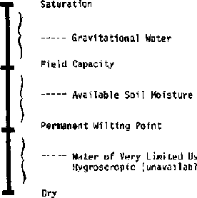
Figure 2-1 illustrates those
soil-moisture concepts.
Since irrigation is to provide water to the soil for plants to use, you should examine the soil. A typical soil can be looked upon as a three-phase system with approximately half the space occupied by solid material, one-fourth by gas, and one-fourth by liquid.
The solid phase consists largely of inorganic materials known as sand, silt, and clay that range from 2 mm to less than 0.002 mm in diameter. Sand particles are the largest (2.00 mm to 0.05 mm) and consist mainly of quartz. Sand has a gritty feeling when rubbed in the hand. Silt particles (0.05 mm to 0.002 mm) have a velvet-like feeling, while clay (less than 0.002 mm), the smallest size fraction, is sticky when moistened in the hand.
Most soils also have a small portion, 0.1 to 10 percent, of organic material which is extremely important because it increases water-holding capacity, improves structure, and provides plant nutrients as it decomposes.
Figure 2-2 illustrates a Soil Texture Triangle used in the United States. The triangle has been divided into regions such as "clay" or "sandy loam" depending upon the relative amounts of various sizes of soil particles present. To read the chart, the clay lines go horizontally to the right from the clay side of the triangle, the silt lines go down at a 45° slope from the silt side of the triangle, and the sand lines go up to the left at a 45° angle from the bottom (sand) side of the triangle.
The various size fractions of the soil are mixed into different combinations called soil textures. For example, a soil texture such as loam consists of 28 to 50 percent silt, 25-52 percent sand, and 7.5 to 27.4 percent clay. Soil containing equal amounts of the three separates is a clay loam.
The various textures indicated on the textural triangle (Figure 2-2) are generally grouped into three categories. Sands, loamy sands, and sandy loams are usually referred to as coarse-textured soils. Loams and silt loams are medium textured soils; while clay loams, silty-clay loams, and clays are known as finetextured soil. The fine-textured or clay soils are known as heavy soils, while coarse-textured soils are called light soils.
The terms heavy and light soils originated from the ease that tillage implements can be drawn through them. Thus, clays are difficult soils to draw implements through in contrast to sands whose tillage requires less power.
The relative proportions of soil particles by size can be shown easily by letting a sample of soil settle in water. Fill a fruit jar about two-thirds full of water. Pour in soil until the jar is almost full. Replace the cover or put one hand tightly over the top of the jar and shake it vigorously. Then put the jar on the table and let the soil settle (Figure 2-3). Allow plenty of time because the very small particles settle slowly.
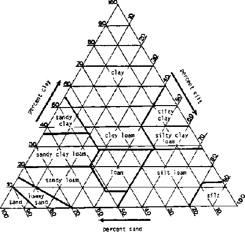
Figure 2-2. The soil texture triangle
(from Handbook No. 436 U.S. Department of Agriculture, Washington, D.C., 1975)
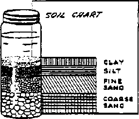
Figure 2-3. Determining approximate
quantities of different sizes of soil particles
Then hold a card or heavy piece of paper against the side of the jar and draw a diagram showing the different layers. Label each layer (clay, silt, sand). Do this with several soils taken from different places and compare the diagrams or compare the jars directly. Soil particles vary greatly in size. The largest (sand) particles settle to the bottom first. The fine (clay) particles settle slowly; some, in fact, are suspended indefinitely.
Soil texture has a large influence on the amount of water it can store for plant use and the rate at which water moves through them (Tables 2-1 and 2-2. The coarse-textured soil can hold for plant use only 20 to 120 millimeters of water per meter depth of soil. At the other extreme, the fine-textured soil will hold from 140 to 200 millimeters per meter of soil. Familiarity with soil textures makes the irrigation design and operation easier and more efficient.
The root zone of plants depends upon the size of the plants. Most major field crops root about 1 to 1¼ meters deep. Most of the roots are nearer the surface, as shown in Figure 2-4. Most water below about 1 meter is essentially unavailable to plants.
Wilting points of most soils are from one-third to two-thirds of field capacity. Table 2-1 shows some typical ranges of available soil moisture to be expected with various soil textures. Irrigation in a typical soil would be required immediately when soil moisture declines to 50 percent of field capacity.
Table 2-1. Range of readily available soil moisture for different soil types
| |
Percent of moisture based on dry weight of soil |
||
|
Soil type |
Field capacity |
Permanent wilting point |
Available water per unit depth of soil, mm/m |
|
Fine sand |
3- 5 |
1- 3 |
20- 40 |
|
Sandy loam |
5-15 |
3- 8 |
40-110 |
|
Silt loam |
12-18 |
6-10 |
60-130 |
|
Clay loam |
15-30 |
7-16 |
100-180 |
|
Clay |
25-40 |
12-20 |
160-300 |
Adapted from: Booker, L. J., Surface Irrigation. FAO Agricultural Development Paper, No. 95, Rome, 1974.
Table 2-2. Long term infiltration rates for indicated soil types
|
Soil type |
Infiltration rate in mm per hour |
|
Clay |
1-5 |
|
Clay Loam |
5-10 |
|
Silt Loam |
10-20 |
|
Sandy Loam |
20-30 |
|
Sand |
Over 30 |

Figure 2-4. Moisture use in relation
to root zone and available moisture (S.C.S. Inf. Bull No. 199)
Most crops in deep, uniform soils use moisture more slowly from the lower root zone than from the upper soil. The top quarter is the first to be exhausted of available moisture. The plant then has to draw its moisture from the lower three-quarters of root depth. That stresses the plant because adequate moisture to sustain rapid growth cannot be extracted by the roots.
Soil structure is a term used to describe the arrangement of the soil particles Structure refers to a compounding or aggregation of soil particles into various forms such as platy, blocky, prismatic, etc. The moisture and air relationships of a soil are influenced by structure. An example of this is when soils containing some clay are trampled by animals while it is wet and the clay fills the pore space, thus creating a denser soil. Upon drying, such soil forms a massive structure and is said to be puddled when dry.
Soil density and pore space
The density of soils is generally measured by two methods, "bulk density" and "particle density." Bulk density refers to the specific gravity of a volume of soil including its pore space. Thus, a cubic meter of soil including its pore space weighing 1,150 kg, divided by the weight of a cubic meter of water, 1,000 kg, has a bulk density of 1.15.
Particle density is a term used to measure the specific gravity of a soil excluding pore space. In other words, we are concerned with measuring the density of the soil particles without considering the air space between particles. Thus, if we assume that the soil just mentioned has a pore space of 48 percent, we can determine the particle density by dividing the weight of the soil particles (1,150 kg) by the weight of an equal volume of water (52 percent of 1,000 kg), 520 kg. The particle density will be 2.22 in this example. For any given soil, particle density will always be greater than bulk density. For most mineral soils, particle density averages about 2.65. Large portions of organic matter will tend to lower this figure. Bulk densities of soils will vary according to the texture and pore space. Bulk densities of coarse-textured soils usually range from 1.3 to 1.8, while fine-textured soils usually range from 1.0 to 1.3. Organic soils, depending upon the content of organic matter, usually range from 0.2 to 0.6.
To eliminate moisture contents as a variable, all calculations involved in determining particle density and bulk density are based on oven-dry weights of soil. Bulk density and particle density of a soil, if known, can be used to determine the "pore space" of a soil with this formula:
PS = 100 - (B.D./P.D. x 100)
where:
PS = pore space in percent
BD = bulk density
PD = particle
density
Substituting the previously determined figures for bulk density and particle density, gives us a pore space of:
PS = 100 - (1.15/2.22 x 100)
PS = 100 - 51.8
PS = 48.2
percent
The percentage of pore space in a soil is important because it determines the amount of water soil can hold when saturated.
Water retention in soils
Water is generally considered to be the universal solvent. The water molecule is dipolar, which means that one end of the molecule is negative in charge and the other is positive. Since opposite charges attract each other, this property permits the molecule to adjust to most materials.
Another property of water is relatively high surface tension. Surface tension is a measure of cohesion or attraction of water molecules to other water molecules. In contrast to cohesive forces, there are the adhesive forces. Adhesion is the attraction of water molecules to other molecules such as glass or soil.
Those soil properties, combined with various soil particle sizes, profoundly influence the movement, storage capacity, and retention of water in soil. Coarse-textured soils consisting of large particles tend to have fewer, but individually larger, diameter pores than fine-textured soils with small particles such as clay. A clay soil will have more total pore space, lower bulk density, and smaller diameter individual pores than a coarse-textured soil such as loamy sand.
Having a relatively high adhesive force, water is retained more in the fine-textured soils than in coarsertextured soils. This can be visualized by comparing the ease with which water can be poured through a two-inch diameter pipe to the difficulty of moving water through a capillary tube.
The relationship of water adhesion to soil particles can also be considered from the viewpoint of specific surface. Specific surface refers to the amount of surface area exposed to air or water. For example' a solid one-inch cube has a specific surface of six square inches. If the same cube is sliced in three places giving eight one-nalf inch cubes, the total surface will be twelve square inches, so a soil such as clay has a high specific surface and, consequently, a high percentage of the water adhering to the particles.
Water infiltration in soils.
The rate that water will move into and through soils is important. Infiltration the rate surface water moves into soil. Percolation is the rate water above field capacity moves downward by gravity.
Infiltration is important because under natural rainfall, infiltration indicates how rapidly water will move into the soil. Low infiltration rates lead to more runoff and, frequently, to soil erosion.
Percolation rates must be high to sustain high infiltration rates. In many soils, layers of various-textured soils influence infiltration rates over long periods. For example, a clay layer beneath a sandy loam area results in a decreased infiltration rate when the sandy loam area becomes saturated.
In some cases, high infiltration rates are not desired. For example, ponds used to store irrigation water should have low infiltration rates. Rice paddies, where permanent flooding is desired, require less irrigation water when infiltration rates are low.
Fine-texture soils generally have lower infiltration rates than coarse-textured soils. The long-term infiltration rate refers to the millimeters of water that enters the soil per hour after a constant infiltration rate has been established. Some values are shown in Table 2-2.
The infiltration rate of a soil, an important factor when designing an irrigation system, may be measured in several ways. Unless large amounts of water are available, the methods are only approximate because if a small surface area is wetted, water will move vertically and laterally. Hence use as large an area as possible when measuring infiltration to minimize the effects of lateral movement, which might not occur during normal rainfall or irrigation conditions.
A measurement technique is to place a wall or dam around a level area to be tested, a 2 to 4 meter square area. Fill the small pond with water and keep the surface of the ground covered. After a length of time, one to a few hours, when ground appears to be well saturated near the surface, determine the rate of infiltration by measuring, usually with a bucket, the rate at which water must be added to keep the surface covered.
For one square meter of area, an infiltration rate of 1 liter per hour equals 1 millimeter (mm) per hour. If a stake is placed in the pond, the rate at which water goes down on the stake could be measured but the meniscus (the curvature of the water surface near a wall) makes this difficult to read.
As an example, a fence around an area is made of lumber enclosing an area of 4 m². After a constant infiltration rate is reached, 50 liters of water must be added to maintain the water level. The infiltration rate is then
50 liters/4 m² = 12.5 liters/hr m² or 12.5 mm/hr.
|
| ||||||||||||||||||||||||||||||
Small Scale Irrigation Systems (Peace Corps)
Section 3. Water and plants
Plant growth comes primarily from converting sunlight, carbon dioxide, and water to carbohydrates, proteins, and cellulose. Other nutrient elements needed in lesser amounts include nitrogen, particularly to form proteins, and a wide range of minerals. Water is needed for plant growth for two purposes:
· It enters directly into the chemical formation of various constituents of the plant.· It serves as a transport mechanism by which nutrients move from the soil to parts of the plant where growth is occurring or it moves chemicals formed by the plant to various plant locations as growth occurs.
Water and carbon dioxide are combined into various carbohydrates by photosynthesis and sunlight furnishes the energy required. The amount of water required for this chemical process is relatively low compared with the amount required to transport other nutrients from the soil to growing parts of the plant. The water required to transport nutrients moves upward in the plant through long capillary tubes (xylem) and is evaporated and transpired through the leaves.
The rate that water evaporates depends on the type of plant. It is very low for desert plants and much higher for most crop plants that grow rapidly.
As water transpires, it causes negative pressure at the roots which then take additional water and soluble nutrients into the plant. Extremely large areas of roots are required to absorb the required water.
Dittmer, measuring the area and length of roots and root hairs of a single four-month-old rye plant, found a total root and root hair length of 11,200 km growing 90 km/day with a total surface area of 639 m².
Transpiration
A large supply of water is necessary for all the activities of plants such as photosynthesis and growth. A young leaf often contains up to 90 percent water. The water content of a leaf at any specific time represents only a fraction of the water reaching the leaf during the growing season. The large water requirement is necessary because water is constantly lost by evaporation from the cells of all aerial parts, especially the leaves.
The leaf has a remarkable structure for capturing carbon dioxide from the air. The undersides of most leaves have a profusion of small openings called stomates. The opening and closing of the stomates is controlled by adjacent guard cells, which are activated by light.
The greater part of water absorbed by plants is lost by transpiration. A vigorous sunflower plant has been estimated to transpire approximately 200 kilograms of water in a 100-day growing season. An individual corn (maize) plant has been calculated to remove 204 liters of water from the soil in a season, 90 times the amount it needed for all other purposes. A mature apple tree may transpire 360 liters of water per day. One hectare containing 88 trees thus would transpire 300 tonnes of water in a midsummer month.
Several external factors greatly influence transpiration rates: radiant energy, air movement, humidity and temperature, and soil conditions. Radiant energy is a dominant factor since the stomata of most plants are open in light. An intensity curve shows a maximum rate of transpiration more or less corresponding with light intensity. Absorption of radiant energy is largely within the visible light spectrum although some of the longer wave lengths (infrared) are also absorbed. Radiant energy absorbed that is not used for photosynthesis is transformed into heat and becomes a factor in water vaporization.
Humidity conditions in the atmosphere are usually expressed as relative humidity. Relative humidity refers to the amount of moisture in the atmosphere at a given temperature compared to the total amount of moisture the atmosphere could hold at the stated temperature. The higher the temperature, the more moisture atmosphere can hold. Thus, if the sub-stomata! air chamber has higher relative humidity than the outer atmosphere, there will be a diffusion gradient (difference in pressure) and water vapor will be lost to the outer atmosphere. A rise in temperature, moderate air currents, and leaf movement also increase transpiration.
Sizes and shapes of leaves affect the amount of water transpired. In general, the modified leaves of such desert plants as cactus lose less water than the leaves of a temperate-region plant such as the sunflower. Water loss is also regulated by the stomata in that when they are completely closed, transpiration is stopped; however, a decrease in diameter of SO to 75 percent apparently has only a slight effect on rate of transpiration
It is apparent that water movement in plants is affected by the water loss from transpiration and the amount of water absorbed from the soil. Some factors that affect the amount of water absorbed from the soil are the extent of the plant root system, the amount of water in the soil, and the concentration of solutes in the soil water.
Root systems
The roots of plants contact the soil and the soil solution and, therefore, absorb water and salts. The plant root system may be viewed as a large probing network that exploits the soil's water and salt resources. The roots also transport water and salts and anchor plants in the soil. There are structurally two main types of root systems--tap root and fibrous root systems. The tap root system consists of a primary or central root that grows more rapidly than any branch roots. Branch roots arise from the central root. In some plants such as carrots, radishes, and beets, the diameter of the tap root may exceed that of the stem.
The fibrous root system has no central axis and most of the branches grow to approximately the same length and diameter. This type of root system may be constituted of relatively thin roots as in annual plants or some parts may grow to larger diameters as in most trees.
Numerous studies of the distribution of root systems have shown that the extent and mass of root development is generally greater than previously supposed. Root growth habits vary with plant species and reflect the influence of soil and climatic factors. In arid regions, alfalfa roots of two-month-old plants have been recorded five feet deep. In general, the more extensive the root system, the greater its absorption capacity.
The depth from which roots of plants can remove moisture from the soil varies with the type of crop. But most annual crops develop root systems that draw most of their water from about the top half meter of soil. Some perennials like alfalfa and trees have deeper root systems and can use more subsoil moisture. Annual plants, such as sorghum, which are commonly grown in semi-arid regions without irrigation, have deeper root systems than such crops as most vegetables and maize (corn) which are commonly grown in more humid climates. Table 3-1 shows the effective rooting depths of some common crops.
Table 3-1. Effective depths for plant roots, cm
|
Plant roots |
Depth, cm |
|
Onion, lettuce |
30 |
|
Pasture, potato, bean, cabbage, spinach, strawberry |
60 |
|
Sweet corn, table beet, peas, squash, carrot, eggplant, peppers |
90 |
|
Sugar-beet, sweet potato, cotton, citrus, lima bean, artichoke |
120 |
|
Melon, flax, maize, small grains |
150 |
|
Alfalfa, asparagus, noncitrus orchard, grapes, hops, grains other than maize, sudangrass, sorghum, tomato |
180 |
Available moisture for plant use
Soil water may be classified as unavailable, available, and gravitational or superfluous. If water is applied to a soil until all pore space is filled, the soil is said to be "saturated." About half of the moisture in saturated soil will be lost to gravity. Usually the gravitational water will drain away within about 24 hours. Except for rather slight losses to evaporation from the soil surface and continuing drainage to gravity, the soil moisture remaining indicates the "field capacity" of that soil.
In practice, field capacity is usually determined two days after an irrigation. A soil will come to field capacity more quickly when an active crop is growing than when no roots are removing water from the soil.
Field capacity can be measured by determining moisture content of soil after an irrigation that was heavy enough to ensure thorough wetting of the soil. Observing the decrease in moisture by making moisture determinations at different times after irrigation is valuable in understanding and properly interpreting the moisture-holding characteristics of a soil.
If there are plants growing on the soil, the moisture level continues to drop until it reaches the "permanent wilting point" (p.w.p.). Soil moisture content near the wilting point is not readily available to the plant. Hence the term "readily available moisture" has been used to refer to that portion of the available moisture that is most easily extracted by the plants, approximately 75 percent of the available moisture. After that, the plants cannot absorb water from the soil quickly enough to replace water lost by transpiration.
Formerly, it was often thought that plants thrive equally well regardless of the moisture level, as long as the level was between field capacity and permanent wilting. It is more logical, however, to assume that if water is abundant enough to be easily absorbed from the soil that plants should thrive better. This is supported by research findings.
Maximum crop yields are obtained when the moisture during the critical growing season is maintained near the upper level of the available soil moisture profile. But when a crop is watered too frequently, even with light irrigations, part of the soil will be so constantly saturated that the crop will suffer from poor aeration.
The soil moisture content when plants permanently wilt is called the permanent wilting point or the wilting coefficient. The permanent wilting point is at the lower end of the available moisture range. A plant will wilt when it can no longer extract enough moisture from the soil to meet its needs. Wilting depends upon the rate the plant uses water, the depth of the root zone, and the water holding capacity of the soil. Crop growth should not be retarded by lack of available soil moisture.
Among the root crops, sugar beets readily indicate need for water by temporary wilting, particularly during the warmest part of the day. Withholding irrigation until the crop definitely shows a need for water is likely to retard growth. It is essential to maintain readily available water in the soil for crops to grow satisfactorily.
Plant roots will not grow into a dry soil, nor will they grow in or into a water logged soil except for rice and a few other crops. Application of excessive amounts of water inhibits root growth and activity, primarily because oxygen becomes unavailable to the plant roots. Plants become yellowish, unthrifty, and slow growing.
|
| |||||||||||||||||||||||||||||||||||
Small Scale Irrigation Systems (Peace Corps)
Section 4. Methods of measuring soil moisture content and availability
Measuring the water storage capacity of soils and the amount of water in soils are vitally important in determining how much water to apply by irrigation. Again, field capacity is the maximum amount of water that a soil can hold against the force of gravity. Water applied to soil beyond field capacity will be lost to deep percolation.
Determining the amount of moisture available to plants in an unsaturated soil is important in calculating the amount of water needed to bring the soil to field capacity. Soils vary in the amount of water they can hold at field capacity. Factors that cause the variation include depth and texture of soil and the percentage of moisture in the soil at the permanent wilting point. Some methods used to determine volumes of water available to crops are considered in the following sections.
Oven dry method
One of the commonest methods of determining soil moisture content is the oven-dry method. It consists of taking a soil sample of approximately 200 grams, determining its exact weight, and drying the sample in an oven at a temperature of 105 to 110 centigrade for 24 hours, then weighing the sample and determining the moisture loss by subtracting the oven-dry weight from the moist weight.
Moisture content is expressed as a percentage of the oven-dry weight of the soil. For example, if a 212-gram moist soil sample weighs 197 grams after drying, the percentage of moisture is calculated by dividing 197 into 15, which gives 7.6 percent. Always subtract the weight of the container from both the moist and dry-weight determinations.
Gypsum-block method
The electrical properties of conductance or resistance can be used to indicate the moisture content of soils. The electrical properties of soils change when moisture content changes. Porous blocks of gypsum containing electrical elements are placed in the soil. The moisture content of the blocks change as the soil moisture content changes.
It has been determined that gypsum (plaster of parts) blocks tend to achieve moisture equilibrium with soil. As the moisture increases, the amount of gypsum in solution increases and the resistance between electrical elements in the block decreases.
Materials such as fiber glass and nylon have also been used for making blocks.
Gypsum blocks operate best at tensions between 1 and 15 atmospheres, while nylon blocks are more sensitive and function best at tensions less than two atmospheres. Because of their volubility, gypsum blocks deteriorate in one to three seasons. Gypsum blocks are less sensitive than nylon and fiber glass blocks to soil salts.
To use gypsum blocks, dig a hole to the deepest depth from which you want moisture data. At each desired interval from the bottom up, bury a gypsum and bring its leads to the surface. Bury a number of blocks at different depths in one location.
It is customary to use a color code for the leads if a series of readings are being recorded at each location. For example, the deep leads might carry a red marker, medium leads a white marker, and shallow leads a blue marker.
Having all red leads indicate the moisture content 4 feet deep greatly simplifies recording.
Small transistorized meters for reading electrical properties are available from commercial outlets, as are gypsum blocks with electrodes and leads installed. Gypsum blocks very widely.
Other still more scientific methods using radio isotopes or tensiometers, available in developed countries, are not discussed here.
Physical appearance and feel method
The oven-dry method is likely the only method measuring soil moisture available to Peace Corps Volunteers in developing countries.
A common method, used by farmers and irrigation technicians alike, is the "feel or physical appearance method." This is a fairly accurate method of measuring soil moisture in the field by taking a soil sample with a soil tube or auger at various depths.
The soil auger is usually nothing more than a carpenter's auger with the screw point and side cutting edges removed. It is light and easy to carry. In soils containing fine gravel, it is frequently difficult, and sometimes impossible, to obtain samples with a soil auger. With a soil tube, it is sometimes possible to cut through gravel layers and still obtain satisfactory samples. The tubes are designed so that (1) they can be pushed into the soil with a minimum of effort, (2) the soil will readily enter the tube, and (3) the tube can be easily extracted from the soil. A portion of the tube is cut away so the soil sample can be inspected when it is taken up.
After the texture of the soil has been determined, the soil sample is first "ribboned" between the thumb and forefinger. If a fairly good ribbon is extruded, soil moisture is usually above 50 percent in the heavier soils. Soils with a very small percentage of clay will not form a continuous ribbon, and the "ball" method should be used. Table 4-1 describes the ball forming method and the percentages of moisture generally left in the soil. Table 4-2 shows water holding capacity of soils.
Table 4-1. Guide for judging how much soil moisture is available for crops
|
Available soil moisture |
Feel or appearance of soil | ||
|
remaining |
Light texture |
Medium texture |
Heavy texture |
|
0 to 25 percent |
Dry, loose, flows through fingers. |
Powdery dry, sometimes slightly crusted but easily broken down into powdery condition. |
Hard, baked, cracked, some times has loose crumbs on surface. |
|
25 to 50 percent |
Appears to be dry, will not form a ball.* from pressure. |
Somewhat crumbly but holds together |
Somewhat pliable, will ball under pressure.* |
|
50 to 75 percent |
Tends to ball under pressure, but seldom holds together. slick slightly with pressure. |
Forms a ball somewhat plastic, will sometimes |
Forms a ball, ribbons out between thumb and forefinger. |
|
75 percent to field capacity |
Forms weak ball, breaks |
Forms a ball, is very pliable, |
Easily ribbons out between |
| |
easily, will not slick. in clay. |
slicks readily if relatively high |
fingers, has slick feeling. |
|
At field capacity (100 percent) |
Upon squeezing, no free water appears on soil, but wet outline of ball is left on hand. |
Upon squeezing, no free water appears on soil, but wet outline of ball is left on hand. |
Upon squeezing, no free water appears on soil, but wet outline of ball is left on hand. |
|
Saturated |
Water appears on ball and hand. |
Water appears on ball and hand. |
Water appears on ball and hand. |
* Ball is formed by squeezing a handful of soil very
firmly.
(S.C.S. Inf. Bull No. 199)
Persons with some experience in irrigation soon become aware that the wetter the soil, the deeper one sinks into the mud. This observation has been used to indicate how well the soil is irrigated.
Inserting a shovel into the soil gives a better indication of soil moisture. A still better method is to use a steel rod about one-half inch in diameter. By pushing the rod into the soil, the depth of wetting can be determined.
These methods, while not highly accurate, are most useful where accurately calibrated instruments are unavailable.
Visual indications of plant moisture deficiency and excess
Growth of most crops produced under irrigation is stimulated by moderate quantities of soil moisture and retarded by either excessive or deficient amounts of moisture. Air is essential to satisfactory crop growth; hence, excessive filling of the soil pore space with water drives out the air and inhibits plant growth.
On the other hand, soils with deficient amounts of water hold it so tightly that plants must exert extra energy to obtain it. If the rate of intake by the plant is not high enough to maintain turgidity of the leaves, wilting will follow. When soil moisture content is somewhere between these two extremes, plants grow most rapidly.
Light green in alfalfa generally indicates an adequate moisture supply and satisfactory growth. Among root crops such as sugar beets, a need for water is generally noted by temporary wilting during the warm part of the day. Grain crops such as maize also will wilt temporarily when moisture is in short supply. In fruit crop production, it is not practical to wait for wilting to detect moisture requirements.
Plant roots will not grow into a dry soil, nor will they grow in or into a water logged soil; rice and a few other crops are exceptions. Application of excessive amounts of water inhibits root growth and activity, so plants develop a yellowish appearance and are unthrifty and slow growing.
Table 4-2. Water holding properties of soils
|
Soil type |
Average moisture holding (field) capacity in mm per m |
Depth of avail- able water per unit depth of soil mm/m |
Amount of water (mm) needed to restore root zone (1 m) when 50% level is reached* |
|
Clay |
250 |
160-300 |
125 |
|
Clay loam |
220 |
100-180 |
110 |
|
Silt loam |
185 |
60-130 |
90 |
|
Silt |
150 |
50-115 |
75 |
|
Sandy loam |
125 |
40-110 |
60 |
|
Fine sand |
85 |
20- 40 |
40 |
* This is probably more than can be applied at one time because lower levels of root zone will not be as dry as upper levels where more roots are withdrawing moisture. Also uniform soil texture is assumed over entire depth, such uniformity seldom exists except in deep alluvial soils along streams.
A particularly critical stage for plants is when seed is germinating and for a short time thereafter as roots develop some depth. To handle this problem at seeding time requires that one of two conditions exist:
1. Seeding is done at a time of the year when normal rainfall will be sufficient to provide moisture for germination. Seeds must be in contact with very moist soil at the surface.
2. If seed must be planted during a normally dry time then the soil should be very well irrigated before or immediately after planting. This problem is very severe where furrow irrigation is used and seed is planted on the ridge. Usually not enough water can be applied to have the top center of the ridge sufficiently moistened by lateral and upward movement of water to the top of the ridge by capillary action.
|
| |||||||||||||||||||||||||||||||||||||||||||||||||||||||||||||||||||||||||||||||||||||||||||||||
Section 5. Water requirements
Where plants are growing water must be added periodically to the soil to overcome the effects of evaporation from the surface of the soil. During early periods of plant growth, while much of the soil surface is exposed to sun and wind, the moisture loss by evaporation predominates. At later stages of crop maturity, much of the soil surface is shaded and protected from wind. Then transpiration water requirements predominate. Evaporation losses are much larger in climates where the relative humidity is low.
Evaporation losses can be estimated by using an open top evaporative pan. A standard pan, used by the U.S. Weather Bureau, has been adopted at meterological stations in many countries. This Class A circular pan is metal, 1.83 m diameter and 25 cm deep. It is mounted on a wooden platform elevated 15 cm above the ground.
All tall vegetation should be removed, or cut short, around the pan. Smaller pan diameters may be used without significantly affecting the results. Daily water loss can be determined by measuring either the depth or the volume of water required to bring the water back to its original level. The level should be low enough (5 to 7 cm below the rim) to keep water from blowing from the pan by strong wind.
Table 5-1 shows constants which may be multiplied by the pan evaporation rate to find the total evaporation-transpiration rate for typical crops. For example, assume that on a day when 8 mm evaporated from a pan then for maize water use would have been 8 m x (30 to 40 percent) or 2.4 to 3.2 mm.
Figures 5-1 and 5-2 show characteristic water-use patterns for maize and sorghum for Kansas conditions. Water use for corn (maize) at about May 1 is low because of low air temperatures and high relative humidities. By about June 1, when sorghum is just germinating (because it is planted about one month later than maize) soil surface evaporation rates have increased with higher temperatures and lower relative humidities. At the end of the season, water requirements drop very low for corn about October 1. Water use does not drop so low that early for sorghum because sorghum plants remain green, and transpiration continues until the plant is killed by frost.
The water use characteristics of these two crops vary by regions of the world but they indicate the wide variations in water consumption throughout a growing season because of climatic and plant growth factors.
The collection of data required to prepare charts such as Figures 5-1 and 5-2 is time consuming and expensive. Most published data show only the seasonal water requirements for crops and is not: very accurate over a wide range of climates If you use such data; use considerable judgment when applying growing season data to particular periods, such as a month, to forecast water requirements
Table 5-2 shows total water use by several major crops in California for the growing season and for the whole year. Table 5-3 shows similar data for western Oklahoma, a semi-arid area Table 5-4 shows water requirements for other crops and areas.
Evaporative losses are a function of temperature, relative humidity, and wind velocity, at the soil surface. Moisture moves upward in the soil by capillary action so light shallow surface tillage will help reduce evaporation losses. Other means of reducing evaporative losses include covering the surface with mulches of leaves, straw and plant residues. Plastic sheets may be used but are generally too expensive in most developing countries.
Table 5-1. Approximate range of- crop factors kc (%)
|
ETC (crop) seasonal |
kc (%) |
ETC (crop) seasonal |
kc (%) |
|
Alfalfa |
90-105 |
Onions |
25-40 |
|
Avocado |
65-75 |
Orange |
60-75 |
|
Bananas |
90-105 |
Potatoes |
25-40 |
|
Beans |
20-25 |
Rice |
45-65 |
|
Cocoa |
95-110 |
Sisal |
65-75 |
|
Coffee |
95-110 |
Sorghum |
30-45 |
|
Cotton |
50-65 |
Soybeans |
30-45 |
|
Dates |
85-110 |
Sugarbeets |
50-65 |
|
Deciduous trees |
60-70 |
Sugarcane |
105-120 |
|
Flax |
55-70 |
Sweet potatoes |
30-45 |
|
Grains (small) |
25-30 |
Tobacco |
30-35 |
|
Grapefruit |
70-85 |
Tomatoes |
30-45 |
|
Maize |
30-45 |
Vegetables |
15-30 |
|
Oil seeds |
25-40 |
Vineyards |
30-55 |
| | |
Walnuts |
65-75 |
Source: From Doorenbos, J and Pruitt, W. O. Crop Water Requirements, Irrigation and Drainage Paper No. 24, Food and Agriculture
Organization, Rome, 1975.;
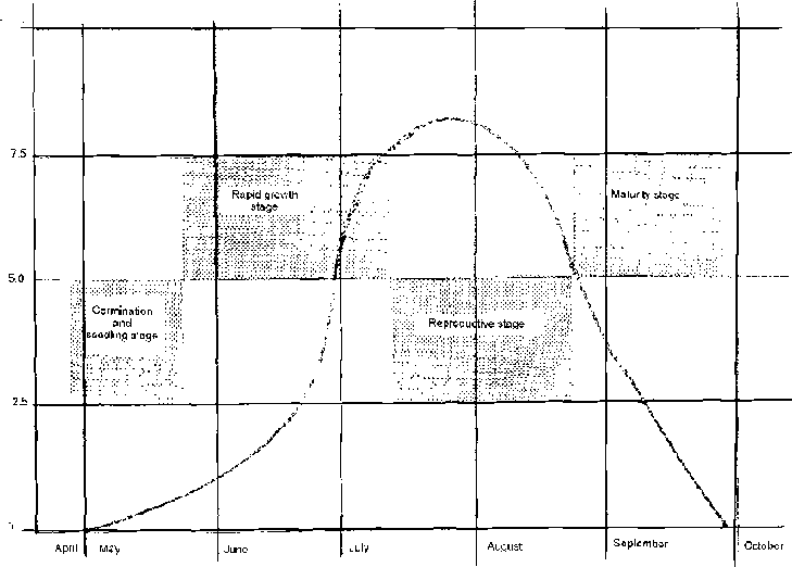
Figure 5-1. Characteristic water use
pattern of maize in Kansas

Figure 5-2. Characteristic water use
pattern for sorghum in Kansas
Table 5-2. Evaporation, California (mm)
| |
Growing season |
Whole year |
|
Celery |
360 |
460 |
|
Haricot beans |
410 |
650 |
|
Potato |
460 |
640 |
|
Onion |
490 |
650 |
|
Grass pasture |
660 |
660 |
|
Fruit |
690 |
760 |
|
Sugarbeet |
700 |
860 |
|
Market gardens |
730 |
800 |
|
Wheat |
740 |
880 |
|
Asparagus |
820 |
820 |
Source: California Department of Public Works, Bulletin No. 27, 1931.
Table 5-3. Water requirements, western Oklahoma (mm)
|
Cotton |
990 |
|
Lucerne |
910 |
|
Bermuda grass |
890 |
|
Wheat |
810 |
|
Sorghum |
740 |
Source: D. O. Anderson, N. R. Cook, and D. D. Badger, Estimation of Irrigation Water Values in Western Oklahoma, (Oklahoma State University, Stillwater, Oklahoma, 1966).
Table 5-4. Plants' supposed water requirements
|
Crop |
Country |
Growing season(months) |
Supposed water requirements (mm/day) |
|
Bananas |
Israel |
12 |
5.7 |
|
Orchards |
Iraq |
12 |
4.7 |
| |
Israel |
12 |
3.7 |
| |
Italy |
12 |
2.3 |
| |
Pakistan NW Frontier |
12 |
2.5 |
|
Lucerne & pasture |
Israel |
12 |
4.7 |
| |
Australia |
12 |
4.3 |
| |
Italy (lucerne) |
6 |
5.0 |
| |
Italy (grass) |
9 |
3.3 |
| |
Australia (lucerne) |
8 |
4.3 |
| |
Australia |
7 |
3.0 |
|
Forest |
Pakistan Punjab |
12 |
3.0 |
|
Sugar-cane |
Pakistan |
11 |
4.0 |
| |
Pakistan NW Frontier |
11 |
4.7 |
| |
Pakistan Punjab |
11 |
4.3 |
| |
Pakistan Punjab |
11 |
4.0 |
| |
Hyderabad |
12 |
6.7 |
|
Cotton |
Pakistan |
7 |
4.7 |
| |
Israel |
8 |
5.3 |
| |
Iraq |
7 |
6.7 |
| |
Pakistan Punjab |
7 |
4.2 |
| |
Pakistan Punjab |
7 |
4.7 |
| |
Hyderabad |
6½ |
5.3 |
|
Rice |
General (see above) |
7 |
7.2 |
| |
Pakistan |
7 |
5.0 |
| |
Pakistan Punjab |
7 |
9.0 |
| |
Pakistan Punjab |
7 |
9.7 |
| |
Pakistan Punjab |
7 |
7.0 |
| |
Hyderabad |
3¼ |
11.0 |
|
Wheat |
Pakistan |
6 |
2.0 |
| |
Pakistan NW Frontier |
8 |
2.7 |
| |
Iraq (inc. barley) |
6 |
3.7 |
| |
Pakistan Punjab |
6 |
1.3 |
| |
Pakistan Punjab |
6 |
2.3 |
| |
Pakistan Punjab |
6 |
1.2 |
| |
Hyderabad |
3 |
4.3 |
|
Sugarbeet |
Israel |
6 |
5.0 |
| |
Italy |
3 |
4.0 |
|
Fodder crops |
Iraq (winter berseem) |
6 |
4.7 |
| |
Iraq (summer) |
5 |
8.3 |
| |
Australia (summer) |
6 |
2.7 |
| |
Pakistan NW Frontier |
| |
| |
(summer) |
4 |
5.1 |
| |
Israel (winter berseem) |
3½ |
8.3 |
| |
Pakistan Punjab (winter berseem) |
3 |
5.3 |
| |
Pakistan Punjab (winter pigeon pea) |
3 |
3.0 |
| |
Pakistan (pigeon pea) |
3 |
6.0 |
| |
Italy (clover) |
3 |
5.3 |
|
Maize |
Israel |
6 |
4.7 |
| |
Italy |
3 |
4.8 |
| |
Pakistan |
6 |
3.3 |
| |
Pakistan NW Frontier |
6 |
3.7 |
| |
Pakistan Punjab |
6 |
2.7 |
| |
Pakistan Punjab |
6 |
3.0 |
| |
Hyderabad |
3¼ |
3.7 |
|
Tobacco |
Israel |
5 |
6.3 |
| |
Australia |
4 |
9.0 |
| |
Hyderabad |
4½ |
7.7 |
|
Tomatoes |
Israel |
5 |
12.0 |
| |
Italy |
3 |
5.7 |
|
Ground-nuts |
Israel |
4½ |
8.3 |
|
Millet |
Iraq |
3 |
6.3 |
| |
Pakistan |
3 |
6.0 |
|
Melons |
Israel |
3½ |
9.0 |
|
Vegetables |
Israel |
3 |
11.0 |
| |
Italy |
4 |
3.2 |
|
Potatoes |
Israel |
3 |
5.7 |
| |
Italy |
3 |
10.0 |
| |
Hyderabad |
3 |
7.0 |
|
Early potatoes |
Israel |
2 |
5.0 |
|
Barley |
Pakistan |
6 |
2.0 |
| |
Hyderabad |
3 |
4.0 |
|
Sorghum |
Pakistan |
6 |
3.3 |
| |
Italy |
3 |
4.7 |
|
Oilseed |
Pakistan |
6 |
2.0 |
|
Beans |
Italy |
3 |
3.3 |
|
Strawberries |
Italy |
5 |
4.3 |
|
Artichokes |
Italy |
6 |
3.8 |
|
Oats |
Hyderabad |
3 |
4.0 |
|
Vines |
Australia |
12 |
2.4 |
|
Citrus |
Australia |
7 |
2.4 |
|
Deciduous fruit |
Australia |
7 |
2.3 |
Source: Finkel, H. J. Handbook of Irrigation Technology, Vol. 1, CRC Press, Inc.
|
| ||||||||||||||||||||
Small Scale Irrigation Systems (Peace Corps)
Section 6. Natural rainfall and irrigation requirements
Because irrigation is normally used to supplement natural rainfall, you must determine the rainfall expected by at least monthly intervals during the crop growing season. The difference between the crop moisture use by month and the natural rainfall expected lets you predict the amount of water that must be available from the irrigation system.
Normally when an irrigation system is used to supplement natural rainfall, the cost of providing the irrigation will be very high--in capital, labor to construct the system, and operation and maintenance costs. To justify the cost, it is usually necessary to increase the crop yield above that expected when moisture is the constraint.
If moisture ceases to be the constraint, then plant population (number of seeds planted per hectare) or soil fertility frequently become the next constraints. If plant population is increased and fertilizer is applied to increase crop production, then a lack of irrigation water at a critical time may lead to disaster. Hence, it is imperative that the source of irrigation water and the distribution system will supply the water required when it is needed.
In regions where irrigation is usually desirable, potentially available and cost effective, natural rainfall varies from month to month or year-to-year and place-to-place. The most easily found rainfall data will show the average annual rainfall for a location for a number of years. Data must be obtained for months and years for (or climatically near), the location where an irrigation system is being considered. Data of such detail is frequently lacking, so the National Meterological Bureau will have to be consulted and the necessary data may have to be tabulated and summarized from individual weather station reports.
Table 6-1 shows rainfall by month over 30 years for one location. Most irrigation specialists recommend designing a system to provide sufficient water for the wettest of the 20 percent driest years. There should be enough water to produce a crop in the driest year but moisture, rather than plant population or soil fertility, would be a limiting factor. With many years (30) of data available, the 20 percent driest year is found by going down the column for one month and locating the six driest years. For the month of January the wettest of the six driest years is the 20 percent driest year (1957) when precipitation was 0.13 inch; dryer years were 1953, 1961, 1964, 1969, and 1970. The same procedure was followed for the other months with the results shown for each month.

Table 6-1. Precipiation in Goodland,
Kansas
To calculate the irrigation requirements, the difference between the natural rainfall for the month and the evaporation-transpiration requirements is calculated. If rainfall is less than crop requirements, the deficit will have to be made up by irrigation. Table 6-2 was prepared using Table 6-1 and Figure 5-2 for June through October, the normal growing season for sorghum in Goodland, Kansas. The second column of Table 6-2 is taken from the bottom row of Table 6-1. The third column, Water Requirements, was prepared as follows.
Table 6-2. Example of irrigation water requirements for sorghum at Goodland, Kansas. (Only the crop growth months, June through October, are considered)
|
Month |
Rainfall, mm |
Water requirements, mm |
Deficiency, mm |
|
June |
34.5 |
60 |
25 |
|
July |
32.5 |
130 |
98 |
|
August |
16.5 |
210 |
194 |
|
September |
7.9 |
150 |
142 |
|
October |
3.8 |
38 |
34 |
|
Total |
95.2 |
588 |
493 |
1/ Taken from Table 6-1.
2/ Taken from Figure 5-2, daily
requirements in inches/day multiplied by days in month
Figure 5-2 shows that the water use for sorghum for June is about 2 mm per day or 60 mm for the month, for July the water requirements range from about 2.5 to 6.0 mm per day. Assuming an average of 4.2 mm per day for the month gives a requirement of 4.2 x 31 = 130 mm for the month. This procedure is continued for the remainder of the season through October 15.
Column 4 is obtained by subtracting Column 2 from Column 3, for June the deficiency is 60 to 34.5 = 25 mm. Results are rounded to the nearest mm.
Table 6-2 is somewhat conservative because it does not consider the soil moisture available on June 1. It also does not show whether during, say July, 194 mm of that irrigation water should be divided into one, two or three applications. That would depend upon soil texture and the irrigation facilities available.
The 194 mm in Table 4-2, could be applied in two applications on a silt loam soil but should be divided into three applications on a sandy-soil type.
Rice culture and irrigation requirements
Rice is the principle grain crop for most Asian countries, where it constitutes the major dietary food. In addition, rice is a commonly used grain in many African, Middle East and South American countries. Rice culture, with the exception of nonirrigated hill land rice, requires special soil, water and agronomic practices that differ from practices used on most other crops.
Numerous variables in varieties of rice, such as plant growth, grain production and tolerance to sodicsaline soils, plus variations in soil texture and structure further complicate rice culture. By relying heavily on averages, common practices and normal situations, however, the following practices generally typify rice culture.
Land Preparation. Proper irrigation of rice depends on how well the depth of water can be controlled, and how uniformly the irrigation water can be applied. A recommended practice is to use contour border levees on six (6) centimeters (cm) of elevational spacing. The 6 cm interval allows a minimum water depth of 10 cm and a maximum depth of 15 cm. Water depths of less than 10 cm are ineffective in controlling grasses, a depth over 15 cm injures rice and often submerges rice seedlings. Level and smooth the seed bed. Water leveling can move large amounts of soil, provides a smooth bed and allows for water depth measurements in the field.
The levees should have a top width of approximately 30 cm and a height of 30 cm and be well compacted to prevent breaking and seepage. Wooden gates should be constructed to control depth of water, remove stress on levees, and provide for field drainage.
Plow the field 15 cm deep and harrow to control weeds before pre-irrigating. Continual use of a uniform plowing depth on rice land builds up a "plow sole" or compacted layer. For most crops, such a layer is not desirable but for rice, it tends to seal the soil and reduce excessive water percolation (water losses) and provides some support for equipment/animals even under flooded conditions.
Pre-Irrigation-Puddling-Planting. Pre-irrigate the fields and puddle the soil with plows an arrows. Rice is usually planted as seedlings and usually by hand in most Asian countries. However it can also be broadcast or seeded by hand or with a grain drill. The soil moisture of the seed bed can be anywhere from saturated to 3 cm of water depth.
Irrigation. Start applying water three days after planting, being careful not to submerge the seedlings. If seeds are broadcast or drilled, wait until seedlings emerge and irrigate after they are 10 to 15 cm high. Increase depth of water as seedlings grow until water is over 10 cm deep. Submerge early maturin varieties continuously at 10 cm deep up to full grain development. Train field two weeks before harvest.
Some rice varieties (low land and late maturing) require drainage to the saturated soil state at the end of the first 30 days or 60 days, respectively. Then they are re-submerged until they mature.
Water Requirements. It is difficult to provide definitive figures for the tote water requirements of a rice crop from seed bed to harvest, because the amount is determined by many factors such as different soil types, growing periods, rice varieties, methods of irrigation, climate, and irrigation efficiency.
Rice usually requires 800 mm to 1,200 mm of water with extremes between 520 mm and 2,550 mm during the growing season. Daily crop water requirements are usually between 6 to 10 mm, however excessive percolation losses in sandy soils can greatly increase water consumption and also increase fertilizer requirements. But sandy soils normally are not recommended for rice culture. The table below shows typical consumption for various soil types by growing rice. The table includes evaporation, transpiration, and infiltration.
|
Soils |
Daily Consumption (mm) |
|
Sand |
26.9 |
|
Sandy Loam |
22.5 |
|
Loam |
17.3 |
|
Clay Loam |
14.7 |
|
Clay |
13.0 |
In addition, the demand for irrigation increases with production (high yielding varieties require more water). Early maturing varieties (100 days) require less water per crop than late maturing traditional varieties that require up to six months for a complete cultural cycle.
It may be safe to conclude that a total of about 1,300 mm of water will be required for the complete growth cycle of rice--40 mm for seedling nursery, 260 mm for land preparation and 1,005 mm for irrigation on a clay loam soil, in a moderate climate.
|
| |||||||||||||||||||||||||||||||||||||||||||||
Small Scale Irrigation Systems (Peace Corps)
Section 7. Topographic mapping and surveying
Land topography surveys and maps are used to measure and describe how the elevation of an area of land varies over distance. If the elevation of Pike's Peak Mountain in Colorado is 4,300 meters, the reader knows that as one moves from the sea coast to Pike's Peak, the elevation will increase from 0 to 4,300; the total distance traveled is not known because the horizontal distance between the sea and the mountain is not stated.
If a house lot is 80 meters long from the street to the back of the lot and the back is 4 meters below the street, then a more adequate description is given and the possibilities of having a "walk-out" basement become evident.
Knowing in great detail the topography of an area to be irrigated becomes very important:
· Water does not flow uphill or even on the level.
· Water flows rapidly down a steep slope so erosion or soil washing may result.
When water is to be moved from one point to another over a land area by gravity, there must be enough slope to cause flow over the surface but not enough slope to cause severe erosion.
The slope of the land along a line may be defined in two ways:
Sloppe = Vertical distance in meters lone / Horizontal distance in meters
Slope, % = [ Vertical distance in meters / Horizontal distance in meters ] x 100
If a field has a 6 percent slope in the direction where elevation changes most rapidly, there will be a difference in elevation of 6 meters vertically to 100 meters horizontally. Note that the longer distance is horizontal, not inclined parallel to the surface of the land. On moderate slopes, it would make little practical difference whether distance were measured horizontally or parallel to the land surface. Figure 7-1 shows the distances and relationships on a slope of 6 percent. With a horizontal distance of 100 m and a vertical distance of 6 m, the inclined distance is the hypotenuse of a right triangle. The square of the hypotenuse of a right triangle is equal to the sum of the squares of the other two sides, hence

Figure 7-1. Illustration of vertical,
horizontal, and inclined distances (not to scale)
There is little inaccuracy involved whether the horizontal distance or sloping distance is used. On the other hand, on a steep slope such as 45 percent, the horizontal distance would be 100 m, the vertical distance 45 m and the sloping distance would be:
(hypotenuse)² = 100² + 45² = 12,025
hypotenuse
= 109.6 m
or there would be about a 10 percent error from using the sloping distance.
If an irrigation ditch is designed for a 1 percent slope in the channel' the horizontal distance need not lie on a straight line, it might be curved.
A contour, or contour line, is a real, or an imaginary, line on an area with zero slope. That is, all points on the line are at the same elevation. If water is allowed to flow naturally over a land surface, as from rainfall, it will always flow in a direction perpendicular to the contour lines.
Although it is standard practice to refer elevations back to sea level, from a practical standpoint it is difficult and unnecessary to do that when making surveys over small areas such as a small irrigation project. For surveys and mapping of small areas, it is acceptable to select same point whose elevation is not likely to change during a limited future time period.
Such a point might include the top of a large rock, a mark on a large tree or a hole might be dug and filled with concrete. In any case, the map should indicate the location of this "bench mark" and describe it. Once a suitable bench mark has been selected, it is given an arbitrary elevation, such as 100.00 meters, all other elevations would then be in relation to the bench mark elevation (rather than to sea level).
To prepare a topographic map, it is customary and convenient to lay out a grid on the area to be mapped by placing markers at each corner of a group of that will cover the area of interest. The corners of the squares normally will be designated by driving short stakes as the squares are measured.
Figure 7-2 is a topographic map of a rectangular map of a rectangular field. The bench mark on the map was located at the approximate center of the field and assigned an elevation of 100.0 m. After two coordinate lines were constructed at right angles through the bench marks, the corners of the squares were located from the two coordinates.

Figure 7-2. Topographic map showing
elevations and contour lines
The size of the squares is arbitrary; the sides might be 5 m, 25 m or 100 m. The shorter the sides, the more accurately the contours may be drawn but more work will be involved in surveying. It is always best to err on the side of more detail.
After locating the corners, the elevation of each corner is determined in relation to the benchmark. When the map is complete with elevations, then contours may be drawn. Again contours might be drawn corresponding to 0.5, 1, 2, etc. meters. If in doubt, use reduced intervals.
On the map shown, contours were constructed as follows:
The 99.0 m contour started at the top of the map at a point "1" where the elevation was exactly 99.0 m.
Point "2" has an elevation of 98.2 m and point "3" has an elevation of 99.4, so there is a point at 99.0 between "2" and "3". By interpolation, the 99.0 m elevation should be nearer 99.4 than 98.2.
The proportion is found by:
L/100 = (99.4-99.0) / (99.4-98.2)
L = 100 (.4) / 1.2 = 33.3 m
Point 4 is then plotted at 33.3 m above the 99.4 elevation. Similar interpolation are made where contours cross coordinate lines.
Land distance measurements
Normally land surveyors use steel tapes when measuring
distances. The tapes are available in various lengths but a length of about 30 m
is common. If extreme accuracy is desired, the tape is leveled with a small
level hung on the tape. To locate the point on the ground where
the elevation
is lowest, a "plumb-bob", or plummet, is suspended from the end of the tape to
locate the point on the
ground.
Land measuring rods
The measurement "rod", is still used sometimes in measuring land. One rod equals 16½ ft. in the English system.
The land measuring rod (spelled "rood" in German ) was brought to England from Germany centuries ago. In Germany, it was 16½ (German ) feet long. Since the German "foot " was slightly longer than the English "foot", the rod became 16 (English) feet long.
When measuring distances on land, using a short measuring tool ( a meter stick or yardstick) is inconvenient. A longer measuring tool, such as a rod or a surveyor's "chain" (4 rods), is more convenient, and simple to construct.
The metric equivalent of a rod is about 5 meters. To construct a rod, take a board 2 to 4 cm square and perhaps 5 m 20 cm long. The extra length is so meter marks do not have to be made at the end of the rod. If boards that size are not available, substitute a strong, straight bamboo pole or other material.
Make marks with a knife at one meter intervals along the rod, beginning about 10 cm from one end. If you label the marks to avoid counting from one end, Roman numerals, etc. are easier to carve than Arabic numerals.
To give a finer measurement at the end of the course, the last meter, between IV and V, might be divided into decimeters (10 cm).
It would be customary to make the fifth decimeter mark a little longer than the others but shorter than the meter marks. Again, the decimeters could be counted or labeled. Centimeters could be estimated fairly accurately between the decimeters marks.
To measure a distance, place the rod on the ground successively making marks in the earth at 5-meter intervals or place markers such as a short piece of wire or nail to mark the end of the rod. Two rods could also be used successively.
Measuring elevations - leveling
Very accurate land surveys would normally use a level with a telescope and cross hairs to sight on a leveling rod resting on the surface of the ground. The surveying level essentially establishes a horizontal plane. Since the telescope is mounted on a base so it can be rotated, the level plane runs in all directions from the centers of the telescope
Figure 7-5 shows a tripod mounted surveying level and a rod to measure the vertical distance between the level plane. If one point is a benchmark with an assumed elevation of 100.00 m, then the level plane is 100.00 + 1.76 or 101.76 m. The other point is 2.42 m below the level plane and its elevation would be 101.76 -2.42 = 99.34 m.

Figure 7-5. Using a surveyor's level
to determine elevation at a point
Figure 7-6 shows a survey that covers a longer distance where the elevations at several points between the benchmark, "BM" and a final point "A" are determined. A survey made in steps is required if there is a visual obstruction between the beginning and end points or when the difference in elevation is great.
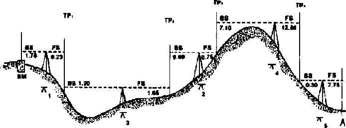
Figure 7-6. Differential survey
The intermediate points are commonly called "turning points." The sight back is called a "backlight" and the sight forward is called a "foresight." The elevation of the instrument is called "height of instrument."
Figure 7-7 shows a typical set of surveying notes for the survey in Figure 7-6. (Note, this example is in feet rather than meters.)
The field note calculations are as follows:
The backlight on the benchmark is 1.78 and this is added to the elevation of the benchmark, 100.00 to give an instrument (horizontal plane) height of 101.78 which is entered under height of instrument, HI on the second row of the notes. The foresight on turning point "1" TP, is 9.23. This is subtracted from the height of instrument to give an elevation of 101.78 - 9.23 = 92.55. The level is then moved ahead and the process is repeated.
Surveyiny levels are relatively expensive, and fragile instruments that may not be available in remote rural areas where PCV's are likely to work. Two much simpler and cheaper leveling devices are described below: the "chorobates" and plastic tube.
When a chorobates is used as a sighting instrument, it must be used with a leveling rod to measure the vertical distance from the line of sight to the ground.
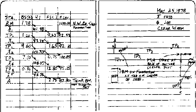
Figure 7-7. Field notes on
differential survey in Figure
7-6
Surveying Levels
Chorobates. Most surveyors now use levels or transits that consist of a telescope with a cross hair to determine the elevation of the "target" Since these instruments are costly and rarely available in rural communities of developing countries, other alternatives may be useful.
The Roman surveyors used a "chorobates" shown in Figure 7-8.*
This level-transit can be made using locally available materials, wood. It can be used as a line-of-sight instrument, similar to a surveyor's level, or as a level, similar to a carpenter's level.
The illustration should be laryely self explanatory and sufficient to build the instrument. The "sights" might be small screw eyes or a piece of sheet metal with a hole bored through for sighting.
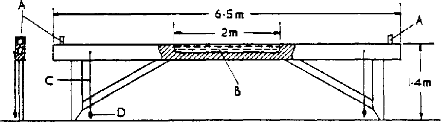
Figure 7-8. Reconstruction of
chorobates, levelling instrument (not from Vitruvius' measurements). No examples
survived. A: sights; B: water channel) C: plumb line; D: plummet
* Copied from The Roman Land Surveyors, O. A. W. Dilke, Barnes & Noble, Inc., New York, 1971.
The water trough would be about 1½ to 2 cm deep and about the same width. It could be cut with a wood chisel. To avoid water soaking into the wood and causing it to warp, the trough should be "waterproofed" with varnish, shellac, oil, wax, pitch, or some other suitable material. Also, do not leave water in the trough when the instrument (chorobates) is not in use.
To see that the instrument is working properly and built right, drive two stakes into the ground until the chorobates indicate the stakes are "level." Then turn the chorobates end-for-end; the water should still be level. If not, look for warpage, unequal leg length, or other factors that might be causing the difficulty.
To use the chorobates as a line-of-sight instrument, drive two stakes into the ground until the instrument is level, then sight ahead to the target on the leveling rod. The difference in elevation between the two points will be the difference in height above the ground of the sights on the chorobates and the target on the rod.
It is always more convenient to survey downhill than uphill.
To use the chorobates as a level, raise the leg on the downhill side until the chorobate's body is level. Then measure the distance from the raised leg to the ground. The distance between the raised leg and the ground is the difference in elevation between the ground at the two legs. A wedge under the raised leg may make leveling convenient.
If a long course is being run and the chorobates is used as a level, it is probably best to drive stakes in the ground for each leg to rest on.
At the end of the course, the distance between the next-to-last and last stake normally will be shorter than the distance between the legs. Set an intermediate stake to the side equidistant from the next-tolast and last stake as shown in Figure 7-9 where ''l'' is the distance between the legs of the chorobates.

Figure 7-9. Chorobates used as a
level
A leveling rod can be constructed much as a land-measuring rod is constructed, but the "O" must be the end of the rod, as shown in Figure 7-10. The overall length could be about 3 m with the rod marked in meters, decimeters, and centimeters. But you may mark in meters and use a meter stick to measure shorter distances.

Figure 7-10. A leveling rod with
marks at one-meter intervals (Distances of less than one meter are measured with
a meter stick)
Attach a moveable target to the rod. It might be a small board held against the rod with a short piece of rubber (from an old inner tube) to hold it in place after the height is adjusted.
When the surveying instrument is sighted on the rod, the target is moved up or down until it is centered on the line-of-sight. The vertical distance is then read.
Plastic tube leveling
If plastic tube is available, it will be faster than a chorobates. Tubing about 6 mm diameter is probably best and it normally is available, in the U.S., in 100 ft. lengths (30.48m). Hence, the difference in elevation between two points about 25 to 30m apart can be measured. When longer courses are to be measured, successive elevations are determined.
To establish the elevation of one point with respect to another for plastic, you calculate as shown in Figure 7-11. For convenience, two stakes are shown; actual ground level will be slightly lower.

Figure 7-11. Leveling with plastic
tubing
The level of the top of the upper stake is assumed to be at 100.00 m, a benchmark elevat on.
The distance from the water level is 9.6 cm or.096m. Hence the elevation of the water level is 100.096 (in actual practice, it is usually not necessary to measure elevations so accurately. The 9.6 cm would probably be read as 10 cm).
The top of the lower stake is 84.4 cm (.844m) below the water level, hence the elevation is 100.096.844 = 99.252.
If surveying notes similar to the ones shown in Figure 7-7 were being made, the notes would be as follows.
|
STA |
BS(+) |
HI |
FS(-) |
Elev. |
|
BM |
.096 | | |
100.000 |
|
INST. | |
100.096 | |
|
|
TPI | | |
.874 | |
ln standard surveying notes HI (height of instrument) corresponds to the term "water level."
Plastic tube usually can be found in chemical laboratories or at chemical supply houses. In the U S., it is available in hardware stores at approximately $0.75 per m.
Rubber tubing could be substituted by inserting a piece of glass tubing in each end.
Filling a tube by pouring in water is possible but slow. Alternatives are to straighten the tube and then coil it in the bottom of a container of water. The tube will fill as it is inserted into the water. Another method is to place a container of water at some elevation, i.e., 1 m above the ground and insert one end of the tube into the water; start siphoning to fill the hose by sucking on the other end and keeping it below the water container. When filling by siphoning, remember to use potable water.
Some elements of geometry
Forming Right Angles. It is frequently necessary to form accurate right angles when surveying land or making instruments. Two practical methods for field use are:
a. The 3-4-5 triangle
A right triangle is formed when the dimensions of the three sides of a triangle are in the ratio of 3:4:5 (ratios of 6:8:10, etc. are also useful). To form the right triangle, form a base of say 4 units of length (Step 1) (Figure 7-12). Then find the intersection of the other two sides, one of three units (at a 90° angle) and one of five units (Step 2). The resulting triangle will contain the desired right angle.
b. Perpendicular to a straight line
Mark off a straight line and locate d point from which a perpendicular will be marked off (Step 1) (Figure 7-13). Mark off equal distances from the selected point (Step 2). For Step 3, draw an arc from each of the two points marked in Step 2, which is a greater distance than one unit of the baseline. In this example, twice the distance of one unit of the baseline is used. The perpendicular drawn through the original center point and the intersection of the two arcs will be perpendicular to the first line.
Locating a North-South Line. Draw a circle on a level surface and mark the center accurately (Figure 7-14). Erect d pole at the center with the top of the pole exactly above the center of the circle. This can easily be done with a plummet. Guy the pole with three guys to hold it accurately in position.
Figure 7-12. Forming a right
triangle

Figure 7-13. Erecting a
perpendicular to a lien

Figure 7-14. Locating east-west and
north-south coordinates
At some time during the morning, the shadow of the top of the pole will just touch the circle, mark this point. At some time in the afternoon, the shadow of the top of the pole will again just touch the circle, mark this point. Now connect the two points to give an east-west line. Draw a perpendicular to the east-west line to obtain a north-south line.
|
| ||||||||||||||||||||
Small Scale Irrigation Systems (Peace Corps)
Section 8. Water source development
Large irrigation systems usually depend upon large streams or rivers for the water source. If the large streams have a constant year-round flow, water may be taken from them by building low diversion dams to raise the water level enough to allow water to be removed by gravity flow through canals. Pumps also may be installed to raise the water level to the distribution canals.
If stream flow is much less than desired during the dry season, high dams can be used to store water from the wet to dry season. Most large irrigation projects are publicly financed as is the development of the land to be irrigated and the system of distribution canals. If a PCV is involved with one of these large projects, it will probably be to assist farmers in using the water effectively.
Underground water supplies are being widely used as a water source and large projects require the use of mechanically powered pumps to raise the water to the surface. These systems are frequently called "tubewell" systems. Since the systems vary widely in size, they may be publically or privately owned. The depth of the water table has a great influence on whether small, private systems are practical.
Frequently in the flat flood plain near a stream or river, the water table, even during the dry season when the stream ceases to flow, may not be too deep to allow groundwater to be tapped. If the water table does not drop more than about 20 feet below the surface, any of a number of different waterlifting devices powered by humans, animals, or mechanical devices may be practical. Centrifugal pumps are often used.
Springs that continue to flow during the dry season are ideal water sources for small private irrigation projects. The spring is at the surface and water will flow by gravity to lower elevations where it can be used. To determine the spring's potential as a water source, the quantity of flow should be measured during the season when irrigation will be required.
Small privately or community owned ponds may be used by damming small streams to store water for irrigation. Some major advantages are:
· Small ponds (micro dams) can be placed in almost any location.
· Gravity flow can usually be used to distribute the water.
· Local labor can be used for construction.
· The water can be used for animals or household purposes.
Major disadvantages are:
· Silting is frequently a problem because runoff from natural rainfall contains eroded soil. It is less of a problem where forests or good grass vegetation exists above the pond.· The soil at the pond site should be relatively impervious (probably one of the clay types) to prevent excessive water loss through the bottom of the pond or the dam.
· Erosion around the end of the dam from excess water can be so severe that it requires a masonry structure to lower excess water to the normal stream level below the dam.
· Some capital investment is required to purchase the pipe and valve required to withdraw water from the pond when needed.
· Ponds should be fenced to protect them from livestock.
· Evaporation will be rapid from the pond surface during the dry season, reducing the amount of water available for other purposes.
Before making a final decision on a water source, determine if there are legal, long standing customs or community constraints against developing the particular source. Contact the Ministry of Agriculture or Land Development officials for information about constraints that most likely apply to using water from streams. A good spring may be considered a community resource for animals and households. Using the water for irrigation, particularly for a private project, could cause friction in the community.
Development of underground water is less likely to encounter legal or community restrictions.
Determination of supply available
Streams. When you consider a stream as an irrigation source, first contact local residents who will know if the stream frequently "dries up.'' If it ceases to flow as often as one year in five, it is of questionable value for long season crops. If it is worth considering, the flow rate during the dry season should be determined by using a float or weir method.
Determining stream flow by the float method is very simple. Select a section where the width and depth of the stream are fairly uniform along a fair distance. Measure the cross sectional area as shown in Figure 8-1.
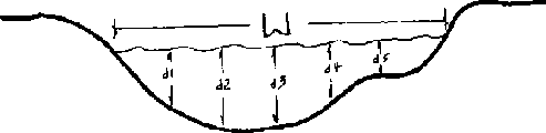
Figure 8-1. Cross sectional area of a
stream used to determine area
If the depth measurements are taken at uniform intervals across the stream, the average depth would be:
And the cross sectional area would be Area = W x dave
To determine velocity, place a small piece of wood on the surface of the water and measure the time it takes to float downstream a given distance. The average stream velocity, V, would be:

The midstream velocity is higher than the average velocity so the velocity measured should be multiplied by 0.8 to obtain an approximate average velocity.
If the cross sectional area is in square meters, the distance in meters, and time "T" in seconds, the flow rate, Q (in cubic meters per second) is:
Q = Area x 0.8 x Velocity
It would be desirable to determine cross sectional area at two or three locations and the velocity should be measured probably three times.
A weir is another useful device for measuring stream flow. Two types of weirs are shown in Figures 8-2 and 8-3. The rectangular weir is convenient for measuring larger flows and the 90° V-notch, triangular weir is most convenient for smaller flows. Figure 8-4 shows the standard bevel used to make a "sharp" crested weir.
The weir may be made of sheet metal or wood. It must be well buried in the bottom and sides of the stream bank to prevent seepage. Posts and braces may be necessary to withstand the pressure of the water on the upstream side.
The effective depth H should be measured from the bottom of the weir notch to a point well upstream (at least 3 times H) as shown in Figure 8-2.

Figure 8-2a.

Figure 8-2b. Rectangular weir
showing critical dimensions
Figure 8-3. Triangular 90°
V-notch weir showing critical dimensions
Figure 8-4. Beveled sharp crested
weir
The formula for the rate of flow through a rectangular weir is:
Q = 1.78 BH1.5
where,
Q = rate of flow in M3/sec
B = width of weir
notch
H = distance from bottom of weir to surface of water well upstream from
the weir
The constant 1.78 depends somewhat on the relative cross section areas of the water upstream from the weir and the area of the weir through which water is flowing. Also, note that the level of water downstream must be below the bottom of the notch.
Figure 8-5 is a special type of chart called a nomograph showing the flow through a rectangular weir as a function of the depth, H. The coordinates on the chart are logarithmic scale rather than linear scale. Also, the flow is in cubic meters per second per meter of width.
As an example of the use of the chart, assume that the depth of water above the notch, H, is 17 cm and the width of the notch, B, is 1.5 m. Going into the chart at H = 17 cm and B = 1.5 m, the line that intersects those two points also intersects Q at 0.18 m³/sec/m.
This value from the chart matches the calculation:
Q = 0.12 m³/sec/m x 1.5m =.18 m³/sec
The formula for flow through a 90° V-notch weir is:
Q = 1.34 H2.48
If the head and depth are given, the width is automatically fixed for a 90° notch.
Figure 8-6 is a chart showing the flow through a V-notch weir as a function of depth. Since flow rates are relatively low, the rate is expressed as liters/sec rather than m³/sec. To use the chart, enter at H at the appropriate depth, draw a line through the pivot point P to the Q scale and read Q. For example, with H = 3 cm, draw the line as shown through P and read Q = 0.16 l/sec.
To measure flow from a spring, a V-notch weir will usually be the preferred solution.
Yield from a hand pumped or animal-power pumped well can usually be determined by measuring the volume in buckets of known capacity. To make the measurement, measure the depth to the surface of the water in the well, probably with a float tied to a string. Starting with time zero when pumping is started, remove a measured volume and determine the time required for the well to refill to the original level.
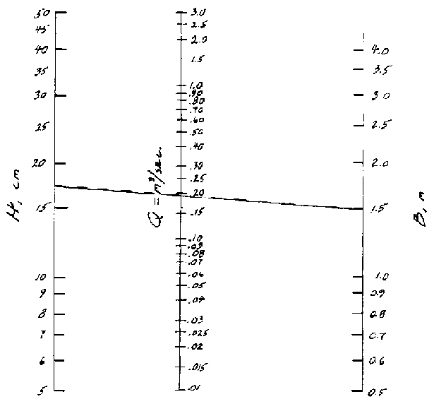
Figure 8-5. Nomograph to determine
flow through a rectangular weir
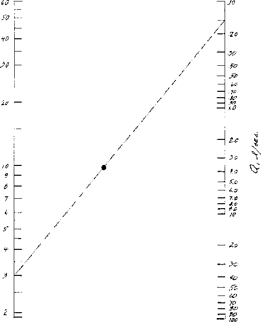
Figure 8-6. Flow through a 90°
V-notch weir
Determining the capacity of a pond to provide water requires some sort of surveying technique. If the pond is empty, a topographic map can be made. If it is not empty, depths can be measured from the surface of the water (a boat may be required) using a rectangular coordinate system. This will require two persons onshore to sight between coordinate stakes set along the bank to line the measuring pole up with the coordinate lines. Prepare a topographic map as shown in Figure 7-2.
An estimate will have to be made of the evaporation expected to occur at various times when water may be needed and the amount of evaporation subtracted from the "bank-full" condition. The average depth of the remaining water over the estimated surface area will provide an estimate of water available for irrigation.
Developing Streams. If the stream banks are very low, a channel canal can be dug to divert water from the stream to the area to be irrigated.
If banks are higher, then a combination of a dam and diversion canal may require less labor than would digging a much deeper canal.
Since most streams have much greater flows during the wet season than during the dry season, most dams must be considered expendable; they will wash out annually and have to be rebuilt before the irrigation season.
Dams may be built of wood, posts and brush, the technique used by beavers. They may be built of earth with some sort of a spillway that will not erode too rapidly to carry excess water, such as a rock-lined channel at one end of the dam, Figure 8-7.
A variety of rock dams may be used that permit surplus water to run over the top without creating excessive erosion. To avoid some of the damage to the dam during high water, enclose stones in wire cages to hold them in place during the irrigation season or throughout the year. Such wire enclosed structures are called "Gabion." Figure 8-8 shows a typical Gabion.
Combinations of a fixed rock or cement spillway with an earthen dam may be feasible. The spillway could be built at one side of the stream to handle surplus water during low flow periods. The earthen dam would then be allowed to wash out during periods of high water and probably would have to be rebuilt annually, Figure 8-7.
If stream banks are very high or if the water must be raised above the stream level, a mechanical pumping devices must be used.
If the stream flow is large compared to the amount of water to be removed, a water powered wheel may be used, Figure 8-9. The large water "sails" furnish the power to raise the partially filled containers to the discharge point. Figure 8-10 is an additional detail diagram to how how pivoted buckets are tipped to empty them.
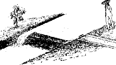
Figure 8-7. Earth dam with masonary
spillway

Figure 8-8. Gabion filled with stone,
lid open
One of the earliest pumping devices was the Archimedes Screw shown in Figure 8-11. It is a very efficient pump and can be powered manually, by animal, water, wind, or other power sources.
Animal power may be applied through rope and pulley arrangements with a single container is used to raise the water to the surface where it is emptied. These devices may be used in dug wells as well as along side streams. Figure 8-12 shows a type of device commonly used in India.
Where water tables are high, the Persian wheels are widely used to lift water from streams or from large dug wells. The wheels are usually animal powered. Figure 8-13 shows a schematic diagram of a Persian wheel, which can be, and usually is, constructed primarily of wood.
Hydraulic rams are useful for raising low water volumes to fairly high elevations. They are water powered devices that require much more water than they deliver. Good information on the construction and installation of rams is available from Peace Corps and VITA publications.
Gasoline, diesel engine or electric motor powered pumps are useful for irrigating from streams or wells. Investment and operating costs are higher than the devices listed above and supplier assistance should be sought when purchasing these units.
A large variety of manufactured pumps are available for pumping from streams or wells. Plans are available from many sources for constructing pumps that use large amounts of modern steel and plastic materials. VITA and similar organizations have numerous publications.
Two types of manually powered pumps which use back and leg muscles rather than arm muscles, are widely used for pumping from shallow wells and streams. The pumps require some imported materials such as aluminum, steel, or polyvinyl chloride (PVC) pipe. The first type is called a "rowers" pump because it requires a rowing type action, Figures 8-14, 8-15, and 8-16. The second type is a pedal type that uses leg muscles, Figure 8-17.
Springs are usually easy to develop because they run from the soil's surface. A small dam or hole is usually sufficient to raise the water from a spring to where it can be used to supply a gravity canal.
Wells are of two general types: (a) large diameter, lined, hand-dug ones--simple to construct and use local materials and labor--and (b) drilled wells of small diameter and lined with steel pipe, PVC pipe, or perhaps even bamboo.
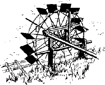
Figure 8-9. Water-powered wheel for
lifting water
Hand dug wells are generally about two meters in diameter or larger to provide enough room for diggers to work and are seldom more than 25 meters deep. If solid rock is encountered, it is easier to use blasting techniques but blasting should be done by persons experienced in using explosives.

Figure 8-10. Detail showing how water
wheel buckets are tipped to empty them
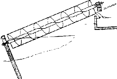
Figure 8-11. Section of Archimedean
screw
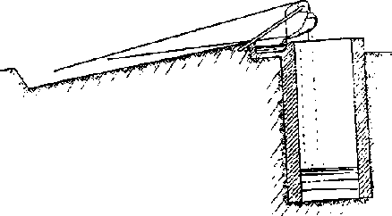
Figure 8-12. Details of Indian mot
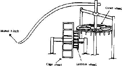
Figure 8-13. Details of Persian
wheel
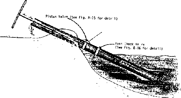
Figure 8-14. Rower pump for a stream

Figure 8-15. Rower pump in a tube
well

Figure 8-16. Valve details for a
rower type pump
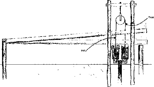
Figure 8-17. Foot operated two-piston
pump
Soil may be removed in buckets by ropes using human or animal power.
As soon as the well depth exceeds about shoulder height, there is danger of dirt caving in and burying the diggers. Shoring should be provided to prevent soil caving. Shoring usually is vertical boards or poles placed next to the circumference, held in place against the wall by freshly cut, flexible poles bent into circles, or part circles, and nailed securely to the vertical poles or boards, as shown in Figure 8-18.
Once the desired depth, which will be well below the water bearing strata, is reached cave-ins are a particular danger because the soil is saturated and the water bearing strata are frequently sandy. Continuous shoring is required and bailing water out of the well may require more time than removing excavated earth.
After the well is completed to the required depth, it should be lined with some type of masonry. Flat rocks may be used; they should provide a wall about 20 centimeters thick or thicker. Concrete blocks might be used but would provide a minimal wall thickness unless one of the ends were placed against the circumference. Bricks might be used but they would have to be placed with mortor. Bricks of not very high quality would probably have a short life. The shoring is simply left in place as the wall is laid but the hoops might be removed as the wall reaches them.
Well digging is a very old practice but the hazards are great. If at all possible, recruit experienced diggers.
Small diameter wells, 1 m to 6 m, and located in deep alluvial type soils without stones may be driven. To "drive" a well, attach a sharp point to one end of a pipe that has a perforated screen above the point to let water flow into the pipe. Cover the other end of the pipe with a cap to keep from damaging it and the threads as it is driven into the ground, Figure 8-19.
If water tables are very high, hand powered boring devices may be used to remove the dirt before the pipe is inserted. Augers used to dig fence post holes are frequently available.
If the soil is essentially rock free, a water-and-casing-pipe technique is used in some countries to dig the hole. To start the hole, use a piece of pipe of the desired diameter filled with water. The pressure of the water will start to wash soil up from the lower end of the pipe.
As the depth increases, the washing is assisted by more positive action. The person using the pipe raises it while tapping the top with one hand. Then the pipe is dropped with the hand removed. Water leaving the top of the pipe carries suspended soil with it. The lower end of the pipe cuts into the dirt and the pipe rubbing against the wall of the hole keeps the hole's diameter large enough for the pipe to fall freely. Short lengths of pipe are added as the hole deepens.
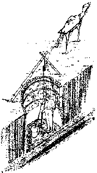
Figure 8-18 Digging a dug well (note
shoring to prevent well cave-in)
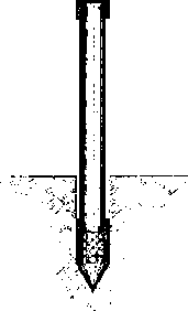
Figure 8-19. Well point, driving cap
and pipe for driving a well
In deep alluvial soils in Bangladesh, wells 30 to 50 m deep can be dug in one day by three or four men using this technique.
Large diameter and deeper wells and those where stones may be present are generally drilled with mechanically powered drilling equipment. Such Jobs are for contractors with the required experience and equipment.
In some locations, water may be collected and conserved during a rainy season to be used in a dry season. For example, land might be levelled between terraces to collect and hold water that would otherwise run off. If the soil is fairly deep and is one of the finer textured soils, the field capacity will provide enough water to increase production of many crops under many climatic conditions.
Some agriculture has developed where water, collected by terraces from a large runoff area, is concentrated into small basins so saturate smaller areas.
Sometimes streams that flow only during heavier rains can be diverted to saturate the soil in a small basin area and fill soil to field capacity for later use.
A more complete reference on well construction by R. E. Brush is, Wells Construction, Manual M-9, Peace Corps, 1982.
|
| |||||||||||||||||||||||||
Small Scale Irrigation Systems (Peace Corps)
Section 9. Water distribution
For most water sources, some sort of a distribution system is required to transfer the water from the source to the area to be irrigated. Most small irrigation systems use small ditches and canals, and the water flows by gravity.
Unlined ditches dug in ordinary soil lose a large amount of water by seepage into the surrounding earth. Part of the seepage might be recovered by growing crops along both sides of the unlined channels.
Seepage losses can be reduced by using linings of masonry, concrete, or plastic sheets, but they are seldom used on small projects in developing countries.
Extraneous vegetation, such as weeds, trees, etc., should be removed to reduce evapo-transpiration losses near the channel.
Obviously, pipes would prevent losses from seepage and evaporation, but the cost of pipes usually prevents them from being used.
Several critical requirements must be met when designing a channel to distribute water:
· To reduce seepage losses, the soil should not be too permeable. If the ditch must traverse an area of very permeable soil, a lining of a heavier soil type might be feasible.· The channel must have enough slope and area to convey the quantity of water required.
· The velocity in the channel must not be so fast that it causes excessive erosion. In extreme cases, masonry or wooden structures may be required to reduce the effective slope.
For very small flow rates, channels may be of V or semicircular cross section; for larger capacities, trapezoidal cross sections are generally used. The side slope on a triangular or trapezoidal cross section will depend upon the soil type. Figure 9-1 shows the three common cross sections.
Side slopes that are too steep will cave off into the channel. The U.S. Bureau of Reclamation recommends a side slope of 3:1 (horizontal: vertical) for sandy soil, about 2:1 for loams and clay loams and as steep as 1:1 or vertical on heavy clay soils. Masonry-lined channels can have vertical sides if they are properly reinforced.
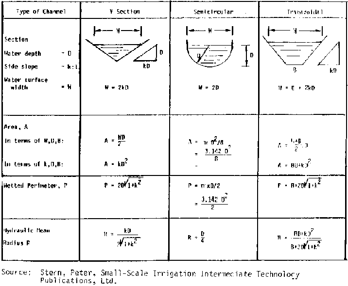
Figure 9-1. The hydraulic
characteristics of channel sections
The velocity of flow in a channel is a function of:
1. Cross sectional shape of the channel,
2. Slope of the
channel, and
3. Roughness of the channel.
The Manning equation is most frequently used to calculate the flow in a channel.
V =[ R2/3 S1/2 ] / n
where,
V = Mean velocity, m/sec
R = Hydraulic radius, m
R = (Area
÷ wetted perimeter)
S = Bed slope in the direction of flow, m/m
n =
Manning roughness coefficient
The hydraulic radius of a channel is defined as the cross sectional area of the channel that the water will occupy divided by the wetted perimeter. Figure 9-1 shows formulas for area, perimeter, and hydraulic radius for three typical cross sections.
The term  occurs in two
formulas for hydraulic radius. Table 9-1 gives the value of
occurs in two
formulas for hydraulic radius. Table 9-1 gives the value of  for typically encountered values of K.
Table 9-1. Table giving  values
|
K |
|
|
1/4 |
1.03 |
|
1/2 |
1.12 |
|
1 |
1.41 |
|
1 1/2 |
1.80 |
|
2 |
2.23 |
|
2 1/2 |
2.69 |
|
3 |
3.16 |

The two-thirds power of hydraulic radius may be read from Figure 9-2, and the sguare root of slope can he taken from Figures 9-3 and 9-4.
Values of "n" for use in Manning's equation are given in Table 9-2.
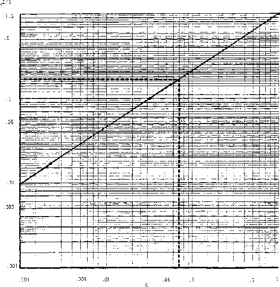
Figure 9-2. Chart to determine the
power of hydraulic radius for Manning's formula
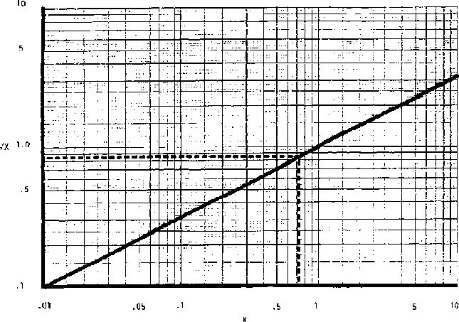
Figure 9-3. Chart for finding the
square root of x (for x =.01 to 10)

Figure 9-4. Chart for finding the
square root of x ( for x =. 00001 ti.01 )
Table 9-2 Values of n for use in Manning's equation
|
Channel material |
Value of n |
|
Earth Channels Straight and uniform |
0.02 |
|
Stony bed, weeds on bank |
0.028 |
|
Small or irrigation channels or drainage ditches |
0.04 |
|
Lined Channels Concrete |
0.015 |
|
Masonry, rubble |
0.017 to 0.030 |
If channel velocities are too great in unlined channels, excessive erosion will occur. Table 9-3 shows maximum recommended channel velocities.
Table 9-3. Permissible channel velocities for carrying clean water
|
Type of soil |
Velocity, m/see |
|
Very fine soil |
0.45 |
|
Sandy loam |
0.55 |
|
Silty loan |
0.60 |
|
Alluvial silts |
0.60 |
|
Dense clay |
1.10 |
|
Alluvial silty, clay |
1.10 |
Although high velocities can cause severe erosion of a channel, very low velocities may cause a different problem. Water from a rapidly flowing stream could be high in sand, silt, and clay that would be carried along by the flow. Such water diverted to a slow-moving irrigation canal would settle out sediment that would require that the canal be cleaned periodically.
Designing the distribution systems
Designing a trapezoidal channel usually requires a trial-and-error solution. One of two general situations will prevail:
· The slope is great enough that the maximum permitted velocity can be obtained or exceeded.· The slope is not great enough to allow the maximum permitted velocity to be reached.
When slope is great enough to allow the maximum velocity to be exceeded, two solutions are possible:
· Reduce the effective channel slope by installing a wood or masonry drop at some point so the slope along the remainder of the channel will be effectively reduced, as shown in Figure 9-5.· Deliberately reduce the hydraulic radius, R, by making a wider and shallower channel.
When the slope is not great enough to permit the maximum velocity to be obtained, select depth values until the required cross-sectional area can be obtained with minimum excavation.
V-shaped channels are easier to design than channels of trapezoidal cross section because depth, rather than both depth and width, is the only variable. V-shaped channels normally will be used when designing channels for relatively low quantities of flow, including furrows in the field.
Example Problem: Assume that a stream 400 m from an irrigated field is to be used for a water source. The water is to be transported in an open channel whose texture is an alluvial silt (the texture usually found in the floodplain along a stream). The elevation of the source is 2m above the upper end of the field to be irrigated. The water requirements are 0.2 m /see at the field. Design the channel, estimate the infiltration (conveyance losses) and determine the amount of water that will be required from the source.
Since the allowable velocity for an alluvial silt is 0.60 m/see (Table 9-3), the ditch area cross section required at the outlet end is derived by the following calculations:
Quality = Velocity x Area

where:
Q = channel flow rate, m³/sec
V = mean velocity of water
in channel, m/sec
A = cross sectional area of channel, m²
Using U.S. Bureau of Reclamation recommendations for side slopes of 2:1, it is now possible to solve Manning's formula for the hydraulic radius required.
From Table 9-2, the value of n = 0.02 would be appropriate for this case.
The slope is:

and from Figure 9-4
S1/2 =.071
Substituting values in the velocity equation

From Figure 9-2 with R2/3 =.17, enter on the left axis, R2/3 at 0.17, move to the right to the curve and down as shown to find R =.07.
Now refer to Figure 9-1, and under the column for trapezoidal cross section find the two equations for area and hydraulic radius.
A = BD + KD²
and

Known values are for A, R and K and unknown values are B and D. Substituting the known values into the two equations gives:
.33 = BD + 2D²
and
Taking the value of  , or
(
, or
( )from Table 9-1 yields 2.23
or,

Now solving for e in the area equation yields:

Substituting this value for B into the hydraulic radius equation yields:

This simplifies to:
.07 (.33 + 2.46D2) =.33D
.023 +.172D2
=.33D
Transposing
.172 D2 -.33D +.023 = 0
Dividing by.172 simplifies to:
D2 - 1.92D +.134 = 0
This is a quadratic equation of the form AX2 + BX + C = 0 which has the solution:

Solving for D:

Using Figure 9-3 to find the square root:

We have to choose whether to use the plus or minus sign:
Choosing "-"

Choosing “+”
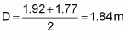
The lesser value of D may be substituted to find B:
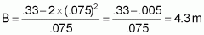
Or using the alternative value of D

Since a negative value of B is a nonsense value, selecting the "+'' sign, which gave D = 1.84, was obviously an incorrect choice of size.
The calculations above were extensive and somewhat difficult. With such a problem, it is worthwhile to use the final values of B and D to find one of the original values. Let us see if the final values of B and D give the original velocity of about.6 m/sec.
Calculate:
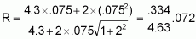

This is very near our original assumed value of.6 m/sec.
Calculated, the total area of the ditch bottom is:
Area = 400 x 4.3 = 1720 m2
The infiltration rate from Table 2-2, assuming a silt loam soil, might be as much as 20 mm/hr or as little as.02 m/hr.
The hourly infiltration would be:
.02 x 1720 = 34 m3/hr
or =34/3600 =.01 m³ /sec
The second value is very small compared with the 0.2 m3/sec, which was needed to irrigate the field and might be neglected except during the first part of the period when the channel bottom was first being saturated.
This channel is very wide compared to the depth and would look somewhat unusual to most persons. However, it is located on a relatively steep slope and the depth and corresponding hydraulic radius were kept small to hold the velocity down. It occupies more land area than may be desirable, but if nonirrigated land is relatively cheap, there should be no great disadvantage.
Since the depth is relatively shallow compared to the width, it would require an excavation of less than 2 cm to obtain enough soil to construct side berms high enough to provide for the 7.5 cm flow depth plus some additional height for safety.
If the extra width were a disadvantage, a wood or masonry drop structure might be located somewhere to reduce the slope for all of the soil part of the channel.
If the slope for the above example were drastically reduced, say to 0.3 m per 100 m and the same calculations then were made when solving for D, the quantity B² - 4AC would be negative and the square root of a negative number is an imaginary number. This is to be a real channel, not an imaginary one, so some changes are required. Really, the problem is that with the reduced slope, it is impossible to reach the maximum allowable velocity.
To solve the problem with the reduced slope, the following approach could be used.
First, calculate the new slope:
S =.3/100 =.003 m/m
Next, assume a hydraulic radius, say 10 cm or.1 m. (The depth in a trapezoidal channel will be somewhere near twice the hydraulic radius, or 20 cm in this case.)
Using Manning's formula and Figures 9-2 and 4:
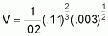
The area required would be:

Assuming that D = 2 x R or.2 m, use the equation for area of a trapezoid from Figure 9-1.
A = B + 2D
.36 = B + 2 x.2

.36 = B +.4 x 2.2
B =.36 -.89 = -.53
It is obvious that the depth selected was too great because B, the bottom width, became negative.
Try R =.05 or D =.1 again


54 = B + 2x.1 x
B =.54
-.4472 =.1 m
Now recheck R with D =.1 & B =.1

Since this value of R is very near our original assumption, it is probably unnecessary to recheck
Construction of the distribution channel
The slope of a channel designed, say to be 2 m in 400 m, has a slope that must be fairly accurately adhered to. Steeper slopes would cause erosion and less slope would increase the depth of flow in the channel.
Starting at the source, a survey should be made to provide a line for the ditch. It will be almost on a contour from the source to the field. If the contour line is quite crooked, it may be "smoothed" or straightened by digging the channel deeper through high points or by filling in low areas with extra earth to build the berms higher.
If the natural slope from the source to the point of use is very steep, it may be difficult to keep the velocity low enough to prevent erosion. A possible solution is to provide, at appropriate intervals, steps that will lower the water from one level to the next (Figure 9-5). The slope of the channel between the "steps" may be kept to a value that will prevent erosion. The steps may be made of wood or masonry materials. The flow velocity will be very high just below the structure and will cause severe erosion on the lower side. An apron must be provided to dissipate the energy in the falling water as shown in Figures 9-6 and 9-7. Table 9-4 shows the dimensions of a typical drop structure as shown in Figure 96(b).

Table 9-4. Dimensions of drop
structures in relation to ditch capacity (refer to Figure 9-6b)
Table 9-4. Dimensions of drop structures in relation to ditch capacity (refer to Figure 9-6b)
|
Capacity of ditch in M³/S |
Width of opening (W) M |
(H) cm |
(C) cm |
M |
|
.05 |
.3 |
30 |
15 |
.6 |
|
.2 |
.6 |
30 |
15 |
.6 |
|
.25 |
.8 |
40 |
15 |
.6 |
|
.3 |
.9 |
45 |
20 |
.8 |
|
1.1 |
45 |
20 |
1 | |
|
Drop (D) M |
| | |
Length of apron (L) M |
|
.3 | | | |
.8 |
|
.5 | | | |
1 |
|
.6 | | | |
1.2 |
|
1 | | | |
2 |
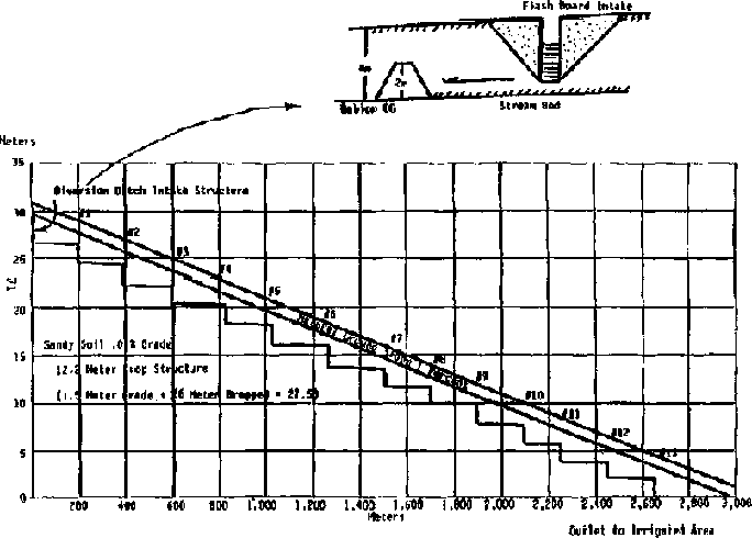
Figure 9-5. Stepped channel to
irrigated area

Figure 9-6. Drop structures
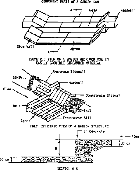
Figure 9-7. Masonry drop structures
If animal power is available, the earth to be removed from the channel may be loosened by plowing. Other methods may be required, depending on specific resources of a project area and country.
Figure 9-8 shows a V-Ditcher that could be drawn by animals to move some of the dirt to the side.
In ditch construction, the V-Ditcher operates quite like an oversized moldboard plow. After a channel line is laid out with surveying instruments, a moldboard plow is used to make a furrow on the line. Then the V-Ditcher is pulled back and forth in the furrow until a symmetrical ditch the size and proportion desired is formed.
One pair of bullocks or more may be used to pull a V-Ditcher. It is important, however, that the bullocks walk on the outside of the channel. Changing the operator's position on the V-Ditcher lowers or increases the depth of cut, which increases the power required to pull it. The width of the ditch may be increased or decreased by lowering or raising the handle of the ditcher.
Distribution channels require some maintenance. Weeds should be removed from berms and the channel to help from increasing flow friction, which would reduce the capacity of the channel. Plant growth on the berms also would increase water loss through transpiration.
In some countries, large animals, such as water buffaloes will pose a significant threat to canal systems. Consideration will need to be made for possible crossings for the animals, and perhaps, as well, for policies regarding grazing alongside the canals. The presence of large water buffaloes, for example, will naturally mean extra maintenance of the canal banks as it is virtually impossible to prevent the animals from wallowing in water and, thus, destroying the canal banks.
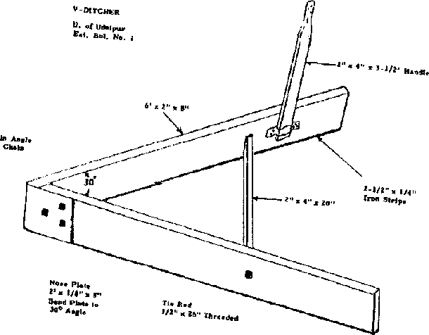
Figure 9-8 V - ditcher for forming
channels or moving dirt to the
side
|
| ||||||||||||||||||||||||||||||||||||||||||||||||||
Small Scale Irrigation Systems (Peace Corps)
Section 10. Field irrigation systems
Basin irrigation
Basin irrigation is one of the oldest methods of irrigating and is widely practiced where rice is irrigated. As explained in Section 6, rice (unlike most crops and most weeds) can grow when the soil is completely saturated. The basin is formed by leveling the area completely and enclosing it with berms, or levees, Figure 10-1. The side berms will run essentially on the contour. If the land is very sloping, the berms become terraces and a large amount of earth must be moved from the upper side to the lower side. On very steep slopes, the basin will be fairly narrow to reduce the amount of leveling required, Figure 10-2. Drop structures are required to lower water from one level to another.
Border Method
With the border method, land is laid out with side berms running downhill on a slight slope. The land is levelled between side berms to make the irrigation water run in a narrow sheet from the upper to the lower end of the field, Figure 10-3. When irrigation starts, the infiltration rate is high at the upper end of the border but, as the soil becomes saturated, the leading edge of the water continues to move downhill. Its rate of forward movement depends on soil type, slope, and quantity of water released. To provide enough water at the lower end of the field without over watering the upper end, a high berm is constructed at the lower end to hold back a pool of water to irrigate the lower end after the supply is cut off.
Determining the correct length and slope of a border system is by trial-and-error, depending upon the factors listed above; however a good starting point can be made as follows.
Lay out the border strip so the lower end is lower than the upper end by about the average amount of irrigation water to be applied in one irrigation.
When the irrigation water has progressed to about 80 percent of the length of the border, cut off the irrigation water and let the residue pond to the lower end. The water that ponds should irrigate the lower end of the border.
Figure 10-3 shows a border type system and water distributed in an almost level system with the pond formed about the time flow is cut off. Figure 10-3 also shows infiltration both during the run and from ponding. The two infiltration rates should provide water over the full length of the border strip.
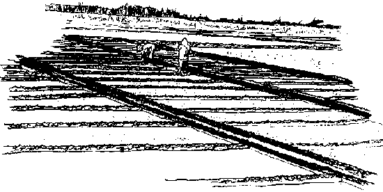
Figure 10-1. Basin type irrigation
system on relatively level land
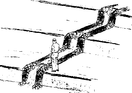
Figure 10-2. A basin type system on
a steeply sloping land
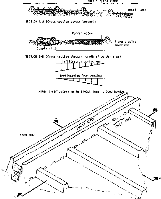
Figure 10-3. Views of a border
irrigation system
Distributing water uniformly across the width of the border strip requires that the level of the soil be very flat (level) across the width of the border. If the border is very wide, water should be supplied at more than one point from the distribution channel.
Obviously the level of water in the distribution channel must be above the level of the land at the upper end of the border. That is, the channel must not be in an excavated area but must be contained between berms. The berms may be formed from excess earth taken from the channel between the water source and the field or from some area not to be irrigated.
The water's level may be raised at the head of the border by placing a small dam across the distribution channel just downstream from the border. This temporary dam may be earthen, a sheet metal dam inserted into the bottom and sides of the channel, or a plastic sheet dam.
The plastic sheet dam is made by rolling several turns of plastic around a wooden pole. The pole is then laid across the channel berms and the sheet laid upstream along the bottom and sides of the channel for a meter or two. The pressure of the water holds the sheet against the bottom and sides tightly enough to prevent leakage.
Leveling across the border will usually be required. It may be done with shovels or other hand tools. An animal-drawn scraper, Figure 10-4, may be convenient for moving earth over short distances. The tail board is provided so the operator can stand on it and provide added weight for cutting soil. The pipe handle is used to provide more, or less, cutting angle.
Water may be discharged from the supply channel to the border by gated pipes through the channel berm or by siphons over the berm. Figure 10-5 shows a wooden pipe with control device and a round pipe turn out. Note now the head "h" is measured depending upon whether the pipe outlet is submerged. Table 10-1 shows the capacities of various sizes of wooden pipes of square cross sections. Table 10-2 shows the capacity of round pipes. Table 10-3 shows typical dimensions for border strips.
Furrow irrigation
The border system is well adapted to watering forage crops or other crops that cover the ground entirely. Crops normally grown in rows, such as grain or vegetable crops, are more frequently irrigated with furrow systems--a series of furrows and ridges with about 75 to 100 cm between furrows and 15 to 20 cm deep, Figures 10-6 and 10-7. The furrows run downhill, as with borders. Where the furrows are constructed 15 to 20 cm deep, it is possible to irrigate a field with a significant amount of side slope.
Rows of tall-growing crops like maize are planted on the ridges. Two rows of low-growing crops like onions may be planted on each ridge.
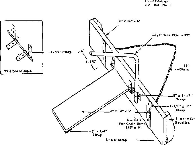
Figure 10-4. Buck scrapper
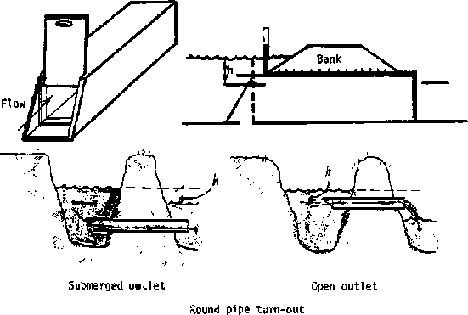
Figure 10-5. Turn-outs to carry water
through a berm to a border or furrow.
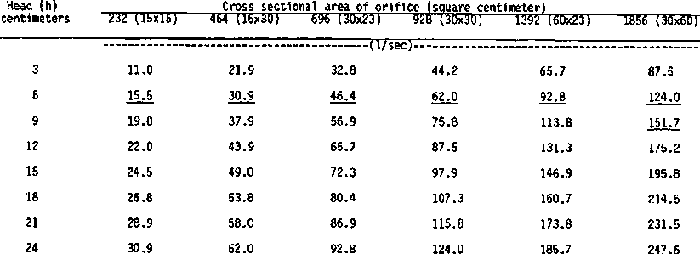
Table 10-1. Flow through rectangular
submerged orifices
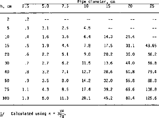
Table 10-2. Capacities of short pipes
in liters/sec
Table 10-3. Suitable dimensions for border strips
|
Type |
Infiltration rate |
Dimensions | |||
| |
of soil (mm/hr) |
Slope (%) |
Width (m) |
Length (m) |
Flow (liters/sec) |
|
Sands |
25 and over |
0.2 |
15-30 |
60-90 |
220-450 |
| | |
0.4 |
10-12 |
60-90 |
100-120 |
| | |
0.8 |
5-10 |
75 |
30-70 |
|
Loams |
7 to 25 |
0.2 |
15-30 |
250-300 |
70-140 |
| | |
0.4 |
10-12 |
90-180 |
40-50 |
| | |
0.8 |
5-10 |
90 |
12-25 |
|
Clays |
2.5 to 7 |
0.2 |
15-30 |
350-800 |
45-90 |
| | |
0.4 |
10-12 |
180-300 |
30-40 |
One problem that may affect row placement on the ridge is having enough soil moisture to germinate seed.
In areas that normally have sufficient rain during the planting season, rainfall should provide moisture for seed germination. In drier areas, the field may be very heavily irrigated just before or after seeding so enough moisture moves side ways and up by capillary action to germinate the seed. But it is usually best to place seeds into moist soil. In severe problem cases, such as a sandy soil and low rainfall, seed may be planted on the side of the ridge so they are closer to the wetted area. Once the seedling root system develops a few inches, there should be no further problems.
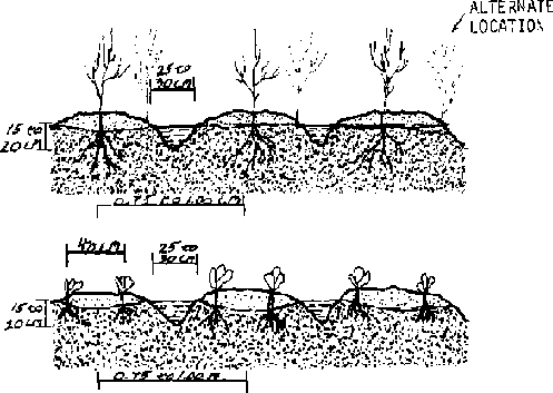
Figure 10-7. Cross section of
irrigation furrows showing plant locations
As with border systems, the slope along the furrow in furrow systems must be flat enough to prevent erosion but steep enough to allow water to reach the end of the furrow. That is so infiltration is relatively uniform the full length of the furrow. The more permeable the soil, the steeper and/or shorter the furrows must be.
In general, furrow slopes should range from 0.1 to 2 percent. The slope must not be steep enough to erode the furrow severely and can generally be greater than the slope of the distribution channel which has a much greater hydraulic-radius value. If the distribution channel is run on a very slight grade, essentially on the contour, then the furrows can be supplied and laid out on the downhill side of the channel although they need not run perpendicular to the channel.
If the field's topography varies widely, it may not be possible to run all furrows parallel and maintain the desired slope. At intervals, it may be necessary to leave an unirrigated a strip of variable width between one set of furrows and another.
Table 10-4 shows some typical lengths and slopes for furrow systems. Because of the many variables involved, a good operating rule is that water should reach the end of the furrow within 25 percent of the total time for one irrigation. That will provide about 25 percent more irrigation at the top of the field than at the lower end. Water to irrigate a furrow can be applied at a high rate at the beginning of the period and then reduced as the soil becomes wetted. That reduces the time required for water to reach the end of the furrow and prevents excessive loss later from the end of the furrow. Also, a dam may be placed at the end of the furrow to pond water and increase infiltration rate.
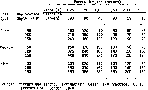
Table 10-4. Typical furrow lengths
for various soil types and slopes Furrow lengths (meters)
Table 10-4. Typical furrow lengths for various soil types and slopes
|
Furrow lengths (meters) | ||||||||
| |
Slope (%) |
|
0.25 |
0.50 |
1.00 |
1.50 |
2.00 |
3.00 |
|
Soil type |
Application |
Discharge |
180 |
90 |
45 |
30 |
22 |
15 |
|
Coarse |
50 | |
150 |
120 |
70 |
60 |
50 |
25 |
| |
100 | |
210 |
150 |
110 |
90 |
70 |
60 |
| |
150 | |
260 |
180 |
120 |
120 |
90 |
70 |
| | | | | | | | | |
|
Medium |
50 | |
250 |
170 |
130 |
100 |
90 |
70 |
| |
100 | |
375 |
240 |
180 |
140 |
120 |
100 |
| |
150 | |
420 |
290 |
220 |
170 |
150 |
120 |
| | | | | | | | | |
|
Fine |
50 | |
300 |
220 |
170 |
130 |
120 |
90 |
| |
100 | |
450 |
310 |
250 |
190 |
160 |
130 |
| |
150 | |
530 |
380 |
280 |
250 |
200 |
160 |
Source: Witkers and Vipond. Irrigation: Design and Practice. B. T. Batsford Ltd. London, 1974.
Sprinkler system
Evaporation is extremely high. Efficient use of irrigation water and minimum land leveling are characteristics of sprinkler systems. But operating and investment costs are higher than for gravity flow systems. Pressures must be matched to sprinkler size and manufacturers' representatives should be consulted to design the systems.
Drip irrigation
Drip irrigation is a relatively new development. With it water is piped under pressure, and small outlets are located at each plant to be watered. The system is usually applied to trees but large plants like tomatoes may be irrigated. The system is designed to apply water very slowly at a rate a specific plant needs. Other areas are not watered.
Major disadvantages of the pressure system are its cost and small holes plugging up with foreign material.
Wild flooding
In this system, water is released from a distribution channel at the top of a field that has had little if any leveling. Water distribution will be very nonuniform. The system should be used only where there is a permanent ground cover such as alfalfa or grass to prevent erosion.
Example problem
A furrow irrigation system is to be designed to supply irrigation water to a crop of maize (corn). The furrows will be approximately 100 m long and the soil type is a clay loam. The furrows are to be placed 1 m apart.
From Table 2-1, the infiltration rate is 5-10 mm/hr. From Table 4-2, 110 mm is required to restore the root zone to field capacity when soil moisture has dropped to 50 percent of field capacity.
With an infiltration rate of 10 mm per hour and 110 mm to be applied, the duration of the irrigation will be:
Time = 110/10 = 11 hours.
The amount of water to be applied per furrow is:
Quantity = 1 m x 100 m x 0.1 m/fur = 10 m³/hr
or
10 m³/3,600 =.0003 m³/sec
or
.0003 x 1,000 = 0.3 liters/sec.
From Table 10-1, a wooden-box field turn-out of 15 x 15 cm with 3 cm head would have more than adequate capacity. It could be closed down after water reached the end of the furrow. From Table 102, a 2.5 cm diameter pipe with 5 cm head would have about the correct capacity. Figure 5-1 shows that maize in Kansas requires about 8 mm of soil moisture per day. In a similar climate, with an application of 110 mm, the irrigation would have to be repeated about each 14 days.
Construction and maintenance
Channels to and within a field require regular routine maintenance to remove weeds that reduce water velocity and cause additional evaporative losses. Some erosion will occur along channels and furrows and some silt deposits will have to be removed to maintain channel cross-section area.
With time berms will erode and require some maintenance to maintain their height.
Originally and with time some levelling of basins and border systems will be required. High and low points should be marked when water covers the surface. Using a large plane of water is a more rapid way to locate high and low spots than using a surveying instrument.
Levelling may be done with shovels and rakes. If animal power is available, a simple float or drag (Figure 10-8) may be efficient and save labor. The wider and longer the drag (or float), the more effective it will be.
Irrigation systems should be checked both before they are needed and during use. Most maintenance probably will require no more than a hoe and shovel. Small leaks, particularly through or over berms should be repaired promptly before water erodes them severely. Watch for holes made by animals through berms.
Erosion during a rainy season can cause serious damage unless the area is well protected with drainage ditches or terraces that divert surface flood-type flow. Drainage is discussed extensively in the next section.
Inspect drop structures frequently to plug leaks around the sides.
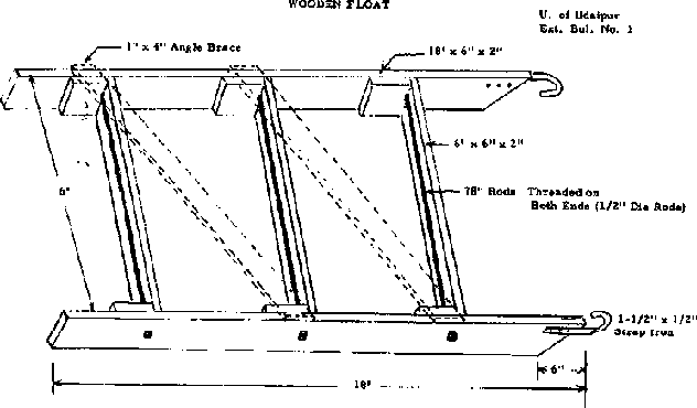
Figure 10-8. Animal powered float for
land
leveling.
|
| ||||||||||||||||||||||||||||||||||||||||
Small Scale Irrigation Systems (Peace Corps)
Section 11. Drainage
Drainage is the removal of excess water from the land to prevent crop damage and salt accumulation, allow earlier planting of crops, increase the root zone, aerate the soil, favor growth of soil bacteria, and to reclaim arable low-lying or swamp areas. Practically every valley where irrigation has been carried on for a considerable length of time has lands needing drainage. To be fit for crop production, several classes of land in irrigated sections require artificial drainage. Man-made swamps, the product of irrigation, often constitute the most of the area needing drainage.
All plans that are developed for introducing water to land, either as a supplemental supply or for new irrigation, should provide for removing excess water from the land.
Drainage problems are usually made apparent by:
1. Standing water or salt deposits on the soil's surface.
2. Scalding of crops by summer water ponding.
3. Propagation of mosquitoes in irrigated fields.
4. Soil compaction and resulting poor water penetration.
5. Difficulty in carrying on farm operations because of poor tractor footing.
6. Salt accumulating in the soil.
7. Poor root growth due to a high water table.
8. Plant root diseases.
9. Development of uneconomical plant communities.
In general, there are two main types of drainage situations; surface and subsurface.
Surface drainage
Surface drainage is affected by topography and vegetation. Excess irrigation water must be removed to alleviate ponding and water logging of the lower parts of the field. Rain water must find its way into a drainage channel without causing erosion and without inhibiting aeration.
On some drainage projects, open ditches are used to convey water to distant outlets. High construction and maintenance costs, the inconvenience of moving machinery, and the value of land removed from production, make open-ditch drainage expensive--and often inconvenient. Still open-ditch construction has a place in many systems. The open ditch, as its name implies, is merely a waterway cut into the soil to receive drainage from adjacent land.
Excess rainfall can be controlled and disposed of by terraces and diversions leading to grassed waterways. On flat land, where there is no erosion hazard, shallow surface drains may be used.
Tail ditches generally are shallow open drains large enough to carry away irrigation waste water and storm water runoff. Storm runoff generally governs capacity. The grade of these ditches should be governed by the soil's resistance to erosion. Banks of the ditches must be protected from surfacewater erosion by inlet structures or by establishing vegetation on flattened slopes.
A combination of field ditches and land leveling is most practical. It would take an unreasonably large network of field ditches to do a good job of moving water from most fields without land leveling. Deep channels to carry the final collection into an accepted area are often constructed on field boundaries.
The first step in solving a drainage problem is to determine the source, direction of movement, and amount of excess water. The permeability or hydraulic conductivity of the soil (the rate of movement of water through the soil) is an important factor. Excess groundwater must be removed by either deep open ditches or tile to provide an effective root zone depth.
Subsurface drainage
Subsurface drainage requires a thorough study of subsurface conditions. Test pits, borings, and permeability tests permit one to evaluate a soil's internal drainage capacity. Borings are commonly used to determine depth and fluctuations of the water table, depth of and thickness of the substrata, and to ascertain the character of the substrata.
The two general methods for removing excess water are by interceptor drains or relief drains. The appropriate method depends primarily on flow characteristics of the water, topographic features of the area, and subsoil conditions.
It is always a good idea to intercept excess water before it reaches the point where damage occurs. For this reason, an interceptor drain should be placed to remove water before it reaches the point of damage. In this case, the tile should be placed as deep as possible to intercept the maximum amount of water flowing downslope.
Relief drainage systems are installed in either a systematic or random pattern within an affected area. These laterals drain water to a main line which in turn discharges it into a trunk drain. Lateral-tile lines are placed parallel to the direction of groundwater movement and often in a gridiron or herringbone pattern.
Tile drains are impractical in many countries because of availability and price of the clay tiles or plastic drain pipe usually used. The design of underground tile drains requires expert engineering talent. The design of such systems is beyond the scope of this manual.
Soil salinity
When soils become too saline for efficient crop production, crops must be removed or the land abandoned. The excess soluble salts in saline soils impair plant growth and soil productivity. One of the first effects of soil salinity is shown by a plant's inability to absorb enough water because osmotic pressure in the soil solution is too great.
Soils in arid-regions contain relatively large amounts of soluble salts. In more humid regions, salts are leached out by rain water. Small rains of the arid regions do not penetrate the soil deep enough to percolate the salts away. Lack of percolation, along with excessive evaporation, causes soluble salts, which are injurious to plant life, to accumulate on the soil's surface. The basic cause of salinity usually is inadequate application of water, poor drainage, or using water a high concentration of soluble salts.
High salt concentrations in the soil may result from a high water table. During periods between irrigations, a high water table favors upward capillary flow of water to the surface where the water evaporates. Soluble salts carried by the upward moving water cannot evaporate, hence, they are deposited on or near the surface.
The most effective way to remove salt from soil is with water passing through the root zone of the soil. To prevent salt accumulations, and consequent decrease in crop yields, irrigators must remove as much salt as is brought in. In some areas, a limited supply of irrigation water is spread over too many acres, with the result that the soil is not wetted below a few feet.
In other areas, the groundwater table is so shallow that it prevents the leaching of salts from the root zone. Upward flow of water from the shallow water tables results in a continuing accumulation of salts in the surface soil. If it were possible to maintain moisture distribution in irrigated soils so the water flow would be continuously downward, there would be relatively little trouble from salinity, even when moderately saline irrigation water was used.
Adequate drainage is extremely important for either reclaiming saline lands or maintaining lands free from salinity. It is usually essential that water volumes in excess of crop requirements be applied to saline and alkaline lands and be made to percolate through the soil to leach out excess salts. Salts dissolve in water that passes through the soil.
In all cases, water must pass beyond the root zone to remove excess salts from the root zone. Leaching therefore, is impossible without natural or artificial drainage.
Enough water should be applied to assure that all the surface is covered, even if ridges and knolls must be leveled first. When the subsoil is impervious, subsoiling must be done. Waste water should not be allowed to run off but should percolate down through the soil. For this reason, a series of dikes and checks should be built to accomplish adequate ponding. Each should have as large an area as slope and water supply permit. Remember that excessive leaching also removes desirable plant nutrients from the soil, especially nitrates. Overuse of irrigation water may also add to drainage problems.
Permanent reclamation of saline and alkali lands requires several essential steps:
1. lowering the water table,
2. satisfactory water infiltration,
3. leaching excess salts from the soil,
4. intelligent future management of the soil.
Some alkali and saline soils that are low in available phosphorous give better crop yields if phosphate fertilizers are used. Liberally applying barnyard manure, plowing under cover crops, and avoiding plowing and other farm operations when the soil is too wet or too dry all help. Keeping drains open and in good repair, applying only enough water to assure adequate penetration into heavy soils, and preventing excessive evaporation are all essential steps in maintaining permanent relief from waterlogging and a continued soil productivity.
Surface runoff
To protect roads, irrigation systems, buildings, and fields, you should determine maximum rate of runoff for all drainage systems. Most structures can be flooded for a short time, but peak rainfall intensities and runoff data should be determined so that the system (bridges, culverts, etc.) can be designed to handle the runoff. It may be most economical to design the structures on a 10- to 25-year recurrence expectancy; that is, the expected runoff would be exceeded only once every 10 to 25 years.
In calculating runoff on small watersheds, this formula has wide usage:
Q = CIA
Q = Expected flood peak, cubic meters per second
C = Runoff coefficient
I = Rainfall intensity, mm per hour
A = Drainage area in hectares
For a drainage area in a diversified farming area, the value of C is often used as 0.50. Some of the figure for C under various conditions are in Table 11-1.
Example problem
An irrigation field is on a flood plain near a stream. Sloping land, 10 percent slope, above the field is used for dryland farming and extends about 1000 meters above the field. The irrigated field is 500 meters long, so it would intercept water running off the steeper slope. Rainfall records indicate maximum rainfall intensities of 100 mm/hr during a recent 10 year period.
How much surface runoff would a diversion channel have to carry to prevent surface runoff water from reaching the irrigated field?
The area to be intercepted is:
A = 1000 X 500 = 600,000 m²
A = 500,000 / 10,000 = 60 Ha
From Table 11-1 the runoff coefficient is estimated to be 0.002. The quantity of runoff then becomes:
Q =.002 X 100 X 50 = 10 m³/sec.
Table 11-1. Runoff coefficients
| |
0-5% Slope |
10-30% Slope |
|
Cultivated land |
0.0018 |
0.002 |
|
Pasture land |
0.0010 |
0.0012 |
|
Timber land |
0.0005 |
0.0006 |
|
| |||||||||||||||||||||||||||||||||||||||||||||||||||||||||||||||||||||||||||||||||||||||||||||||
Section 12. Economic evaluation and feasibility
You have now reached the point where an accurate cost-benefit analysis can be made of a proposed irrigation system. A typical example of such an analysis follows.
A stream may be dammed to provide a water source. A stone masonry wall, which will wash out during the rainy season, can be constructed using an estimated 1,000 hours of labor to gather stones and construct the dam. This will have to be repeated each year.
A distribution channel will be required which is 3 m wide, 12 cm deep, and 800 m long. The estimated time to construct this channel is 2,000 man-hours. Each year, 200 hours will be required to maintain channels.
A furrow irrigation system is to be formed to cover 10 hectares. The estimated time to level the land and dig the furrows is 4,000 hours. Wooden farm turn-outs will be installed to serve three furrows from each turn-out, 50 turn-outs will be required and will cost $0.50 each when made by a local carpenter and will be replaced each year at a total cost of $25 per year.
The field will be used to produce maize. Production costs and yields and returns are shown in Table 12-1. It shows that additional production costs will be required for seed, fertilizer, pesticides, labor, and taxes.
The tabulated costs and returns show that providing irrigation without additional inputs of improved seed and fertilizer would not increase yields enough to justify the additional irrigation costs. If improved crop technology is assumed, however, the nonrecurring cost for digging the channel should be easily justified by the additional $252 per hectare net return.
The tabulated economic analysis is a traditional approach to project analysis from a developed country viewpoint where economic criteria are based upon the principle of "maximizing profit."

Table 12-1. Production costs and
returns in dollars per hectare
Table 12-1. Production costs and returns in dollars per hectare
| |
Traditional rainfed crop |
Irrigated with traditional technology |
Irrigated with improved crop technology |
|
Production Costs | |||
|
a. Seed |
4.00 |
5.00 |
20.00 |
|
b. Fertilizer |
- |
- |
140.00 |
|
d. Animal power |
43.00 |
45.00 |
50.00 |
|
e. Labor, crop production |
15.00 |
30.00 |
40.00 |
|
f. Labor, Dam construction & system maintenance |
- |
120.00 |
120.00 |
|
g. Turn-outs |
- |
25.00 |
25.00 |
|
h. Taxes |
2.00 |
3.00 |
7.00 |
|
TOTAL COSTS |
64.00 |
228.00 |
412.00 |
|
Returns | |||
|
a. Yield (MT/ha) |
2.00 |
3.00 |
7.00 |
|
b. Gross return @ $120/MT |
240.00 |
360.00 |
840.00 |
|
Net Returns |
176.00 |
132.00 |
428.00 |
|
| |||||||||||||||||||||||||||||||||||
Small Scale Irrigation Systems (Peace Corps)
Section 13. Health and safety
Health and safety aspects of working on projects in a developing country are far different from a developed country. Peace Corps Volunteers going abroad receive various immunizations needed for a particular area and are provided anti-malaria drugs as required. Some other health and safety aspects are important, regardless of the Volunteer's assignment. And other health factors relate particularly to irrigation activities.
Safety tips for small irrigation projects
Sanitation/Project Campsite Health. In many cases, small projects will be remote and time consuming to commute to, hence a small project campsite is usually established.
A few simple amenities and/or precautions should be used.
a. Never establish camp along a stream--locate in a well-drained bank above flood level.b. Excavate a simple latrine 75 feet from quarters.
c. Provide for boiling or chemically treating and/or filtering drinking water.
d. Elevate sleeping quarters above ground to reduce snake hazards.
e. If possible obtain old oil drums to collect rainfall for bathing--thus avoiding use of streams and allowing for disinfecting water.
f. Have a complete first aid kit available and a first aid manual.
g. Have a snake bite kit available and/or anti venom if supplies can be properly preserved and a knowledgeable person is available for its usage.
h. Store an emergency food supply such as Army or Forest Service rations.
i. Have mosquito nets.
Always have in your possession a copy of Where There Is No Doctor by David Werner (published by the Hesperian Foundation and available from ICE) or some useful medical manual for lay persons.
Snake and Insect Protection. Most snakes, lizards, scorpions and other reptiles/insects with venomous bites or stings tend to avoid man, except when caught unaware. The following suggestions will help prevent snake bites and poisonous insect stings:
a. Wear boots and loose fitting clothes.b. Avoid tall grass or dense brush.
c. Do not put hands under rocks or in holes without a careful check.
d. Some snakes, such as the bamboo viper, are colored to match the environment they live in. Know the reptiles/insects in your work area.
e. Use caution and make some noise so snakes are aware of your presence, then allow them time to move away.
f. When leeches attach to your skin, do not pull them off. Use a lighted cigarette or match on their rear portion and they will drop off. If available, a bag of wet tobacco can be used to knock them off.
g. Use insect repellents if available.
Brush clearing
a. Avoid personally using machetes for brush clearing. The local villagers are very skilled in using local tools and improper usage can be dangerous.b. Ask local persons to identify poisonous plants such as poison ivy.
c. Be cautious if burning is used in brush clearing operations--stay upwind to prevent the danger of clothing catching on fire. Some poisonous plants like poison ivy make poisonous smoke.
Excavations. When digging village wells or embankment cuts, always "shore" up the walls with timber, especially in sandy soils. Never work on unshored cuts more than chest high. A cubic meter of soil weights approximately one ton and has great crushing force.
Miscellaneous suggestions
a. Be careful when working in or around swift streams or streams with debris or tree snags.b. Do not work in streams during flood season.
c. Avoid overexertion or excessive exposure to heat or sun.
d. Avoid walking around during the night and have good flashlights.
e. Avoid village work animals and dogs until they become familiar with your presence. Your scent differs from local people's and work carabao (water buffalo), for example, are very docile with villagers, but resent strangers with a different scent.
f. Keep the local villagers informed of your activities--as you gain their confidence they will offer useful suggestions. Take advice! Check security!
g. Do not enter isolated areas unless there are at least two companions with you.
h. Always have adequate fuel in a vehicle.
i. When traveling in a boat, wear a life jacket.
j. Observe land marks and/or mark your trail to avoid getting lost in jungle or swamps.
k. Observe good housekeeping in camp. Garbage attracts rats, which attract snakes. Store tools, equipment, and materials properly. Keep work areas clean and neat.
l. Keep the cooking area clean and sanitary and observe good food handling practices.
m. Store flammable materials away from open fires--provide for extinguishers if possible.
n. Wear gloves when using hand tools and hard hats around construction.
Water related diseases
The health aspects of irrigation development are typically neglected and can impose large social costs on the community. Table 13-1 shows preventive strategies for some of the common diseases associated with water.
Table 13-1. Classification of water-related diseases and prevention strategy
|
Category |
Example |
|
1. Faecal-oral (water-borne or water-washed | |
|
(a) low-infective dose |
Cholera, amoeba |
|
(b) high-infective dose |
Bacillary dysentery, ascariasis |
|
2. Water-washed |
|
|
(a) skin and eye infections |
Trachoma, scabies, leprosy, yaws |
|
(b) other |
Louse-borne fevers |
|
3. Water-based |
|
|
(a) penetrating skin |
Schistosomiasis |
|
(b) ingested |
Guinea worm, paragoniniasis |
|
4. Water-related insect vectors | |
|
(a) biting near water |
Sleeping sickness |
|
(b) breeding in water |
Malaria, onchoceriasis |
|
Transmission mechanism |
Preventive strategy |
|
Water-borne |
Improve water quality; and pre- vent casual use of other unimproved sources. |
|
Water-washed |
Improve water quantity; improve water accessibility; and improve hygiene. |
|
Water-based |
Decrease need for water contact; control snail populations; and improve quality. |
|
Water-related insect vector |
Improve surface water management; destroy breeding sites of insects; and decrease need to visit breeding sites. |
Source: Bradley, O. J. "The Health Implications of Irrigation Schemes and Man-made Lakes in Tropical Environments," in R. Feachen, M. McGary, D. Mara (eds) Water, Wastes and Health in Hot Climates, (Wiley, London, 1977).
One specific disease Schistosomiasis is a particular and severe hazard when working in irrigation water. Symptoms are discussed in the references. Consult local medical advice before starting an irrigation project.
If possible, avoid irrigation projects in areas of watersheds where Schistosomiasis exists; however, in Egypt, the problem is endemic and cannot be avoided. Physical protection using boots is recommended. Heavy canvas "stockings" impregnated with oil may be effective if rubberized boots are not available.
|
| |||||||||||||||||||||||||||||||||||||||||||||||||||||||||||||||||||||||||||||||||||||||||||||||
Suggested references
Crop Production
1. Improved practices in Corn Production, ICE.
2. Soils,
Crops and Fertilizer Use, ICE.
3. Rice Production, ICE.
Extension
("Non-formal Education)
1. Agricultural Extension, ICE.
Health
1. Werner, David. Where There is No Doctor. Hesperian Foundation, VITA and ICE.
Irrigation
1. Booker, L. J. Surface Irrigation, FAO Agricultural
Development Paper., No. 95. Rome, 1974.
2. Finkel, H. J. Handbook of
Irrigation Technology, Vol. 1, CRC Press, Inc. Boca Raton, Florida, 1982.
3.
Jensen, M. E. Design and Operation of Farm Irrigation Systems, American Society
of Agricultural Engineers. St. Joseph, Michigan, 1980.
4. Schwab, G. O., R.
K. Fievert, T. W. Edminister and K. K. Barnes. Soil and Water Conservation
Engineering. John Wiley, 1966.
5. Stern, Peter. Small Scale Irrigation,
Intermediate Technology Publications, 9 King St. London WC2 8HN, United Kingdom,
1979.
6. Withers, B. and S. Vipond. Irrigation Design and Practice. B. T.
Batsford Ltd., 4 Fitzhardinge St., London W1H OAH, 1974.
Wells
1. Using Water Resources. VITA.
2. Construction and
Maintenance of Water Wells for Peace Corps Volunteers. VITA, 1979.
3. Brush,
Richard, Wells Construction, Peace Corps, 1982.
4. Koegel, R. C. Self Help
Wells. FAO, Rome, 1977.
5. Watt, S. B. and W. E. Wood. Hand Dug Wells and
Their Construction.
VITA.
|
| |||||||||||||||||||||||||||||||||||||||||||||||||||||||||||||||||||||||||||||||||||||||||||||||
Measures and conversions
Metric
1 Kilometer (Km) = 1,000 meters (m)
1 m = 100
centimeters (cm)
1 decimeter (dm) = 10 cm
1 cm = 10 millimeters (mm)
1
Hectare (Ha) = 10,000 m²
1 Liter = 1,000 cm³
1m³ = 1,000 liters
English
1 mile = 5,280 feet (ft)
1 rod = 16½ ft
1
ft = 12 inches (in)
1 gallon = 231 in³
1 Acre = 43,560 ft²
Conversions
1 inch = 2.54 centimeters
1 mile = 1,609
meters
1 gallon = 3.78 liters
1 ft³ = 7.48 gal
1 Hectare = 2.47
Acres
1 m³ water = 1,000 kilograms water
1 liter water = 1
kilogram = 1,000 gram
1 m³ water = 1 metric ton (tonne)
1 gal water =
8.34 lb
1 ft³ water = 62.4 lb
Small scale irrigation
systems
Contents