
| Small Scale Irrigation Systems (Peace Corps) | ||||
| Section 8. Water source development | ||||
| (introduction...) | ||||
| Determination of supply available | ||||
|
| ||||||||||||||||||||
Large irrigation systems usually depend upon large streams or rivers for the water source. If the large streams have a constant year-round flow, water may be taken from them by building low diversion dams to raise the water level enough to allow water to be removed by gravity flow through canals. Pumps also may be installed to raise the water level to the distribution canals.
If stream flow is much less than desired during the dry season, high dams can be used to store water from the wet to dry season. Most large irrigation projects are publicly financed as is the development of the land to be irrigated and the system of distribution canals. If a PCV is involved with one of these large projects, it will probably be to assist farmers in using the water effectively.
Underground water supplies are being widely used as a water source and large projects require the use of mechanically powered pumps to raise the water to the surface. These systems are frequently called "tubewell" systems. Since the systems vary widely in size, they may be publically or privately owned. The depth of the water table has a great influence on whether small, private systems are practical.
Frequently in the flat flood plain near a stream or river, the water table, even during the dry season when the stream ceases to flow, may not be too deep to allow groundwater to be tapped. If the water table does not drop more than about 20 feet below the surface, any of a number of different waterlifting devices powered by humans, animals, or mechanical devices may be practical. Centrifugal pumps are often used.
Springs that continue to flow during the dry season are ideal water sources for small private irrigation projects. The spring is at the surface and water will flow by gravity to lower elevations where it can be used. To determine the spring's potential as a water source, the quantity of flow should be measured during the season when irrigation will be required.
Small privately or community owned ponds may be used by damming small streams to store water for irrigation. Some major advantages are:
· Small ponds (micro dams) can be placed in almost any location.
· Gravity flow can usually be used to distribute the water.
· Local labor can be used for construction.
· The water can be used for animals or household purposes.
Major disadvantages are:
· Silting is frequently a problem because runoff from natural rainfall contains eroded soil. It is less of a problem where forests or good grass vegetation exists above the pond.· The soil at the pond site should be relatively impervious (probably one of the clay types) to prevent excessive water loss through the bottom of the pond or the dam.
· Erosion around the end of the dam from excess water can be so severe that it requires a masonry structure to lower excess water to the normal stream level below the dam.
· Some capital investment is required to purchase the pipe and valve required to withdraw water from the pond when needed.
· Ponds should be fenced to protect them from livestock.
· Evaporation will be rapid from the pond surface during the dry season, reducing the amount of water available for other purposes.
Before making a final decision on a water source, determine if there are legal, long standing customs or community constraints against developing the particular source. Contact the Ministry of Agriculture or Land Development officials for information about constraints that most likely apply to using water from streams. A good spring may be considered a community resource for animals and households. Using the water for irrigation, particularly for a private project, could cause friction in the community.
Development of underground water is less likely to encounter legal or community restrictions.
Streams. When you consider a stream as an irrigation source, first contact local residents who will know if the stream frequently "dries up.'' If it ceases to flow as often as one year in five, it is of questionable value for long season crops. If it is worth considering, the flow rate during the dry season should be determined by using a float or weir method.
Determining stream flow by the float method is very simple. Select a section where the width and depth of the stream are fairly uniform along a fair distance. Measure the cross sectional area as shown in Figure 8-1.
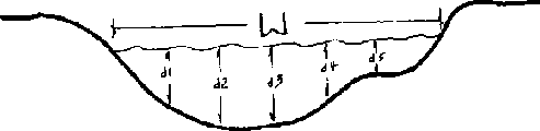
Figure 8-1. Cross sectional area of a
stream used to determine area
If the depth measurements are taken at uniform intervals across the stream, the average depth would be:
And the cross sectional area would be Area = W x dave
To determine velocity, place a small piece of wood on the surface of the water and measure the time it takes to float downstream a given distance. The average stream velocity, V, would be:

The midstream velocity is higher than the average velocity so the velocity measured should be multiplied by 0.8 to obtain an approximate average velocity.
If the cross sectional area is in square meters, the distance in meters, and time "T" in seconds, the flow rate, Q (in cubic meters per second) is:
Q = Area x 0.8 x Velocity
It would be desirable to determine cross sectional area at two or three locations and the velocity should be measured probably three times.
A weir is another useful device for measuring stream flow. Two types of weirs are shown in Figures 8-2 and 8-3. The rectangular weir is convenient for measuring larger flows and the 90° V-notch, triangular weir is most convenient for smaller flows. Figure 8-4 shows the standard bevel used to make a "sharp" crested weir.
The weir may be made of sheet metal or wood. It must be well buried in the bottom and sides of the stream bank to prevent seepage. Posts and braces may be necessary to withstand the pressure of the water on the upstream side.
The effective depth H should be measured from the bottom of the weir notch to a point well upstream (at least 3 times H) as shown in Figure 8-2.
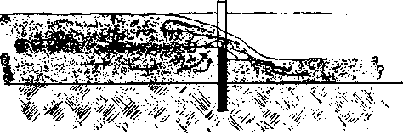
Figure 8-2a.

Figure 8-2b. Rectangular weir
showing critical dimensions
Figure 8-3. Triangular 90°
V-notch weir showing critical dimensions
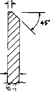
Figure 8-4. Beveled sharp crested
weir
The formula for the rate of flow through a rectangular weir is:
Q = 1.78 BH1.5
where,
Q = rate of flow in M3/sec
B = width of weir
notch
H = distance from bottom of weir to surface of water well upstream from
the weir
The constant 1.78 depends somewhat on the relative cross section areas of the water upstream from the weir and the area of the weir through which water is flowing. Also, note that the level of water downstream must be below the bottom of the notch.
Figure 8-5 is a special type of chart called a nomograph showing the flow through a rectangular weir as a function of the depth, H. The coordinates on the chart are logarithmic scale rather than linear scale. Also, the flow is in cubic meters per second per meter of width.
As an example of the use of the chart, assume that the depth of water above the notch, H, is 17 cm and the width of the notch, B, is 1.5 m. Going into the chart at H = 17 cm and B = 1.5 m, the line that intersects those two points also intersects Q at 0.18 m³/sec/m.
This value from the chart matches the calculation:
Q = 0.12 m³/sec/m x 1.5m =.18 m³/sec
The formula for flow through a 90° V-notch weir is:
Q = 1.34 H2.48
If the head and depth are given, the width is automatically fixed for a 90° notch.
Figure 8-6 is a chart showing the flow through a V-notch weir as a function of depth. Since flow rates are relatively low, the rate is expressed as liters/sec rather than m³/sec. To use the chart, enter at H at the appropriate depth, draw a line through the pivot point P to the Q scale and read Q. For example, with H = 3 cm, draw the line as shown through P and read Q = 0.16 l/sec.
To measure flow from a spring, a V-notch weir will usually be the preferred solution.
Yield from a hand pumped or animal-power pumped well can usually be determined by measuring the volume in buckets of known capacity. To make the measurement, measure the depth to the surface of the water in the well, probably with a float tied to a string. Starting with time zero when pumping is started, remove a measured volume and determine the time required for the well to refill to the original level.
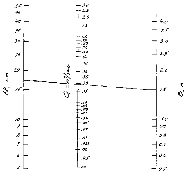
Figure 8-5. Nomograph to determine
flow through a rectangular weir
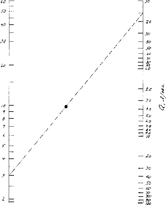
Figure 8-6. Flow through a 90°
V-notch weir
Determining the capacity of a pond to provide water requires some sort of surveying technique. If the pond is empty, a topographic map can be made. If it is not empty, depths can be measured from the surface of the water (a boat may be required) using a rectangular coordinate system. This will require two persons onshore to sight between coordinate stakes set along the bank to line the measuring pole up with the coordinate lines. Prepare a topographic map as shown in Figure 7-2.
An estimate will have to be made of the evaporation expected to occur at various times when water may be needed and the amount of evaporation subtracted from the "bank-full" condition. The average depth of the remaining water over the estimated surface area will provide an estimate of water available for irrigation.
Developing Streams. If the stream banks are very low, a channel canal can be dug to divert water from the stream to the area to be irrigated.
If banks are higher, then a combination of a dam and diversion canal may require less labor than would digging a much deeper canal.
Since most streams have much greater flows during the wet season than during the dry season, most dams must be considered expendable; they will wash out annually and have to be rebuilt before the irrigation season.
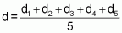
Dams may be built of wood, posts and brush, the technique used by beavers. They may be built of earth with some sort of a spillway that will not erode too rapidly to carry excess water, such as a rock-lined channel at one end of the dam, Figure 8-7.
A variety of rock dams may be used that permit surplus water to run over the top without creating excessive erosion. To avoid some of the damage to the dam during high water, enclose stones in wire cages to hold them in place during the irrigation season or throughout the year. Such wire enclosed structures are called "Gabion." Figure 8-8 shows a typical Gabion.
Combinations of a fixed rock or cement spillway with an earthen dam may be feasible. The spillway could be built at one side of the stream to handle surplus water during low flow periods. The earthen dam would then be allowed to wash out during periods of high water and probably would have to be rebuilt annually, Figure 8-7.
If stream banks are very high or if the water must be raised above the stream level, a mechanical pumping devices must be used.
If the stream flow is large compared to the amount of water to be removed, a water powered wheel may be used, Figure 8-9. The large water "sails" furnish the power to raise the partially filled containers to the discharge point. Figure 8-10 is an additional detail diagram to how how pivoted buckets are tipped to empty them.
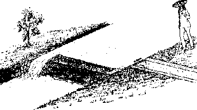
Figure 8-7. Earth dam with masonary
spillway

Figure 8-8. Gabion filled with stone,
lid open
One of the earliest pumping devices was the Archimedes Screw shown in Figure 8-11. It is a very efficient pump and can be powered manually, by animal, water, wind, or other power sources.
Animal power may be applied through rope and pulley arrangements with a single container is used to raise the water to the surface where it is emptied. These devices may be used in dug wells as well as along side streams. Figure 8-12 shows a type of device commonly used in India.
Where water tables are high, the Persian wheels are widely used to lift water from streams or from large dug wells. The wheels are usually animal powered. Figure 8-13 shows a schematic diagram of a Persian wheel, which can be, and usually is, constructed primarily of wood.
Hydraulic rams are useful for raising low water volumes to fairly high elevations. They are water powered devices that require much more water than they deliver. Good information on the construction and installation of rams is available from Peace Corps and VITA publications.
Gasoline, diesel engine or electric motor powered pumps are useful for irrigating from streams or wells. Investment and operating costs are higher than the devices listed above and supplier assistance should be sought when purchasing these units.
A large variety of manufactured pumps are available for pumping from streams or wells. Plans are available from many sources for constructing pumps that use large amounts of modern steel and plastic materials. VITA and similar organizations have numerous publications.
Two types of manually powered pumps which use back and leg muscles rather than arm muscles, are widely used for pumping from shallow wells and streams. The pumps require some imported materials such as aluminum, steel, or polyvinyl chloride (PVC) pipe. The first type is called a "rowers" pump because it requires a rowing type action, Figures 8-14, 8-15, and 8-16. The second type is a pedal type that uses leg muscles, Figure 8-17.
Springs are usually easy to develop because they run from the soil's surface. A small dam or hole is usually sufficient to raise the water from a spring to where it can be used to supply a gravity canal.
Wells are of two general types: (a) large diameter, lined, hand-dug ones--simple to construct and use local materials and labor--and (b) drilled wells of small diameter and lined with steel pipe, PVC pipe, or perhaps even bamboo.
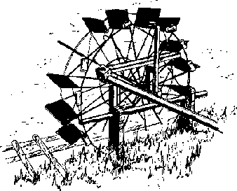
Figure 8-9. Water-powered wheel for
lifting water
Hand dug wells are generally about two meters in diameter or larger to provide enough room for diggers to work and are seldom more than 25 meters deep. If solid rock is encountered, it is easier to use blasting techniques but blasting should be done by persons experienced in using explosives.

Figure 8-10. Detail showing how water
wheel buckets are tipped to empty them
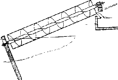
Figure 8-11. Section of Archimedean
screw
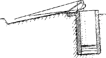
Figure 8-12. Details of Indian mot
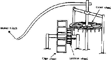
Figure 8-13. Details of Persian
wheel
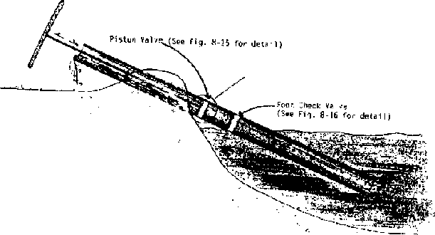
Figure 8-14. Rower pump for a stream

Figure 8-15. Rower pump in a tube
well

Figure 8-16. Valve details for a
rower type pump
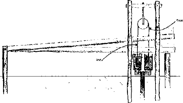
Figure 8-17. Foot operated two-piston
pump
Soil may be removed in buckets by ropes using human or animal power.
As soon as the well depth exceeds about shoulder height, there is danger of dirt caving in and burying the diggers. Shoring should be provided to prevent soil caving. Shoring usually is vertical boards or poles placed next to the circumference, held in place against the wall by freshly cut, flexible poles bent into circles, or part circles, and nailed securely to the vertical poles or boards, as shown in Figure 8-18.
Once the desired depth, which will be well below the water bearing strata, is reached cave-ins are a particular danger because the soil is saturated and the water bearing strata are frequently sandy. Continuous shoring is required and bailing water out of the well may require more time than removing excavated earth.
After the well is completed to the required depth, it should be lined with some type of masonry. Flat rocks may be used; they should provide a wall about 20 centimeters thick or thicker. Concrete blocks might be used but would provide a minimal wall thickness unless one of the ends were placed against the circumference. Bricks might be used but they would have to be placed with mortor. Bricks of not very high quality would probably have a short life. The shoring is simply left in place as the wall is laid but the hoops might be removed as the wall reaches them.
Well digging is a very old practice but the hazards are great. If at all possible, recruit experienced diggers.
Small diameter wells, 1 m to 6 m, and located in deep alluvial type soils without stones may be driven. To "drive" a well, attach a sharp point to one end of a pipe that has a perforated screen above the point to let water flow into the pipe. Cover the other end of the pipe with a cap to keep from damaging it and the threads as it is driven into the ground, Figure 8-19.
If water tables are very high, hand powered boring devices may be used to remove the dirt before the pipe is inserted. Augers used to dig fence post holes are frequently available.
If the soil is essentially rock free, a water-and-casing-pipe technique is used in some countries to dig the hole. To start the hole, use a piece of pipe of the desired diameter filled with water. The pressure of the water will start to wash soil up from the lower end of the pipe.
As the depth increases, the washing is assisted by more positive action. The person using the pipe raises it while tapping the top with one hand. Then the pipe is dropped with the hand removed. Water leaving the top of the pipe carries suspended soil with it. The lower end of the pipe cuts into the dirt and the pipe rubbing against the wall of the hole keeps the hole's diameter large enough for the pipe to fall freely. Short lengths of pipe are added as the hole deepens.
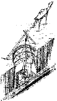
Figure 8-18 Digging a dug well (note
shoring to prevent well cave-in)
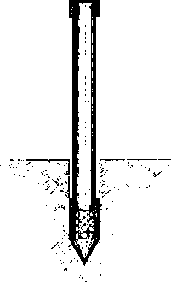
Figure 8-19. Well point, driving cap
and pipe for driving a well
In deep alluvial soils in Bangladesh, wells 30 to 50 m deep can be dug in one day by three or four men using this technique.
Large diameter and deeper wells and those where stones may be present are generally drilled with mechanically powered drilling equipment. Such Jobs are for contractors with the required experience and equipment.
In some locations, water may be collected and conserved during a rainy season to be used in a dry season. For example, land might be levelled between terraces to collect and hold water that would otherwise run off. If the soil is fairly deep and is one of the finer textured soils, the field capacity will provide enough water to increase production of many crops under many climatic conditions.
Some agriculture has developed where water, collected by terraces from a large runoff area, is concentrated into small basins so saturate smaller areas.
Sometimes streams that flow only during heavier rains can be diverted to saturate the soil in a small basin area and fill soil to field capacity for later use.
A more complete reference on well construction by R. E. Brush is, Wells Construction, Manual M-9, Peace Corps, 1982.